The Common Bay


Manifesto

The Pearl River Delta has nurtured a prosperous urban agglomeration by offering valuable ecosystem services as common goods. However, eco-commoning is increasingly exclusive and diminishing because the current development model in the Great Bay Area prioritizes the economic prosperity of core cities, while the region faces challenging shifts, such as climate change, industrial transformation, and demographic change.

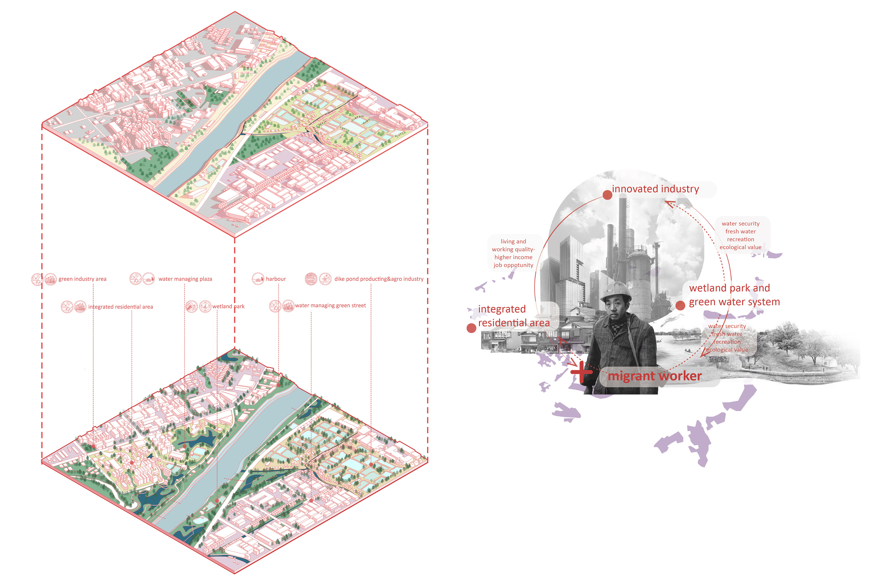
The unequal distribution of commoning leads to socio-economic and environmental vulnerabilities. Vulnerable groups, particularly the elderly, left-behind children, low-income producers, and migrants, bear double burdens. Additionally, dynamic edge areas that serve as catalysts for the production of eco-common goods are particularly sensitive as they are at the intersection of eco-social vulnerabilities.

We hope to facilitate environmental justice in the Great Bay Area by recognizing the PRD's ecosystem services as common goods and increasing their access and availability to vulnerable groups in sensitive edge areas. By placing the needs of most vulnerable at the forefront of design, we believe it could increase the resilience of many that face the risks of double vulnerabilities.

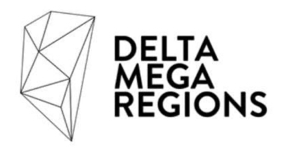
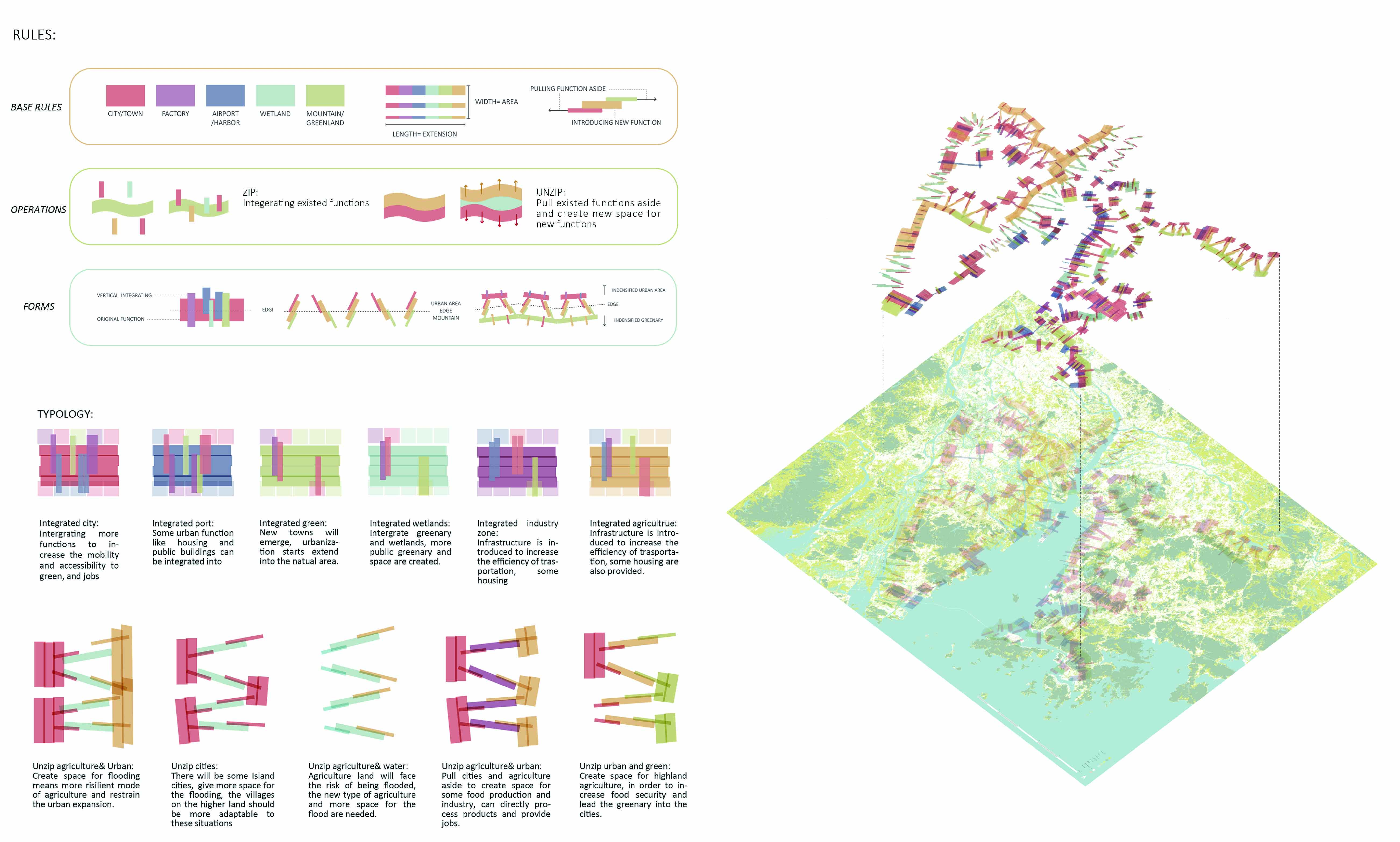
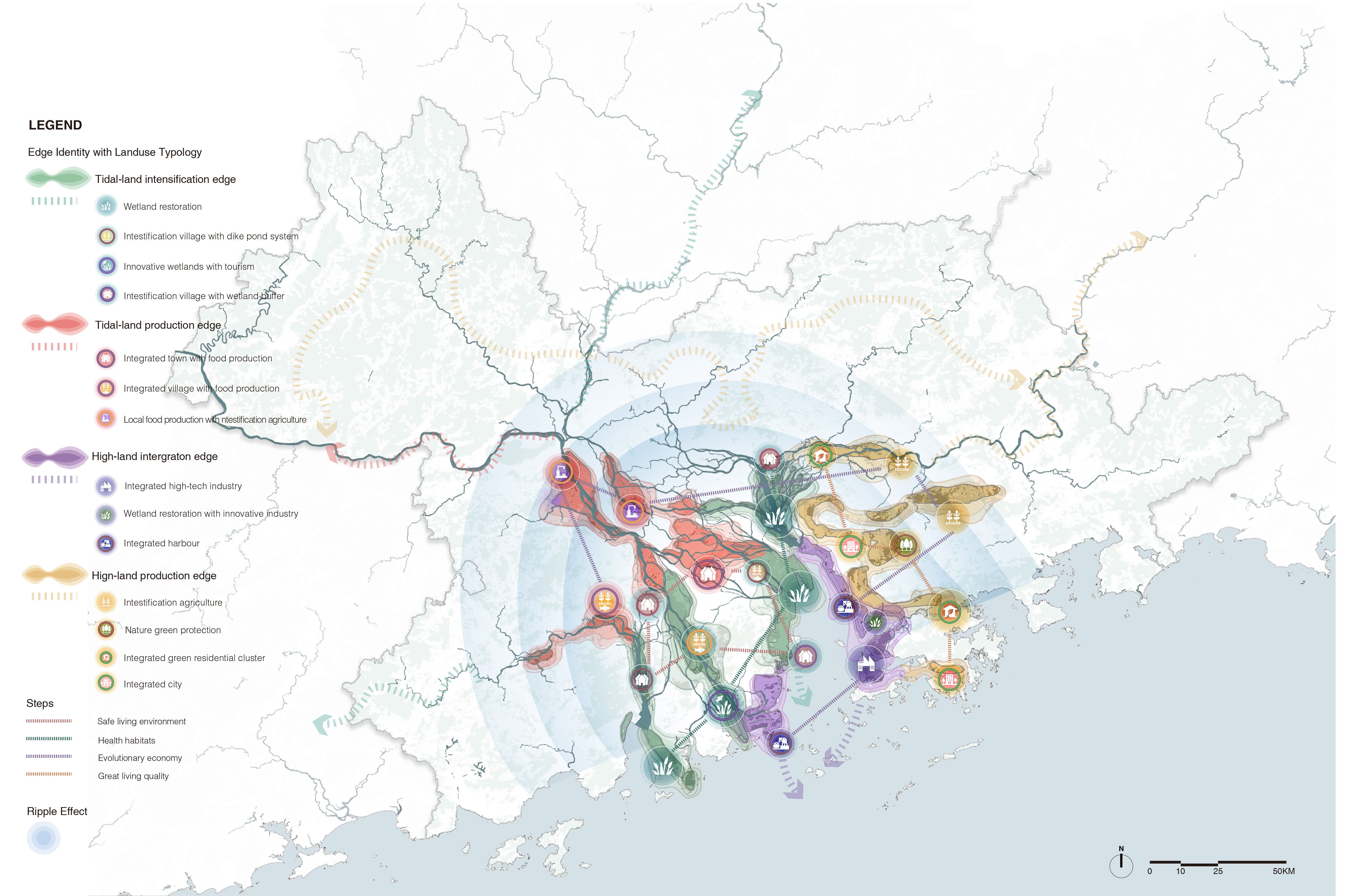
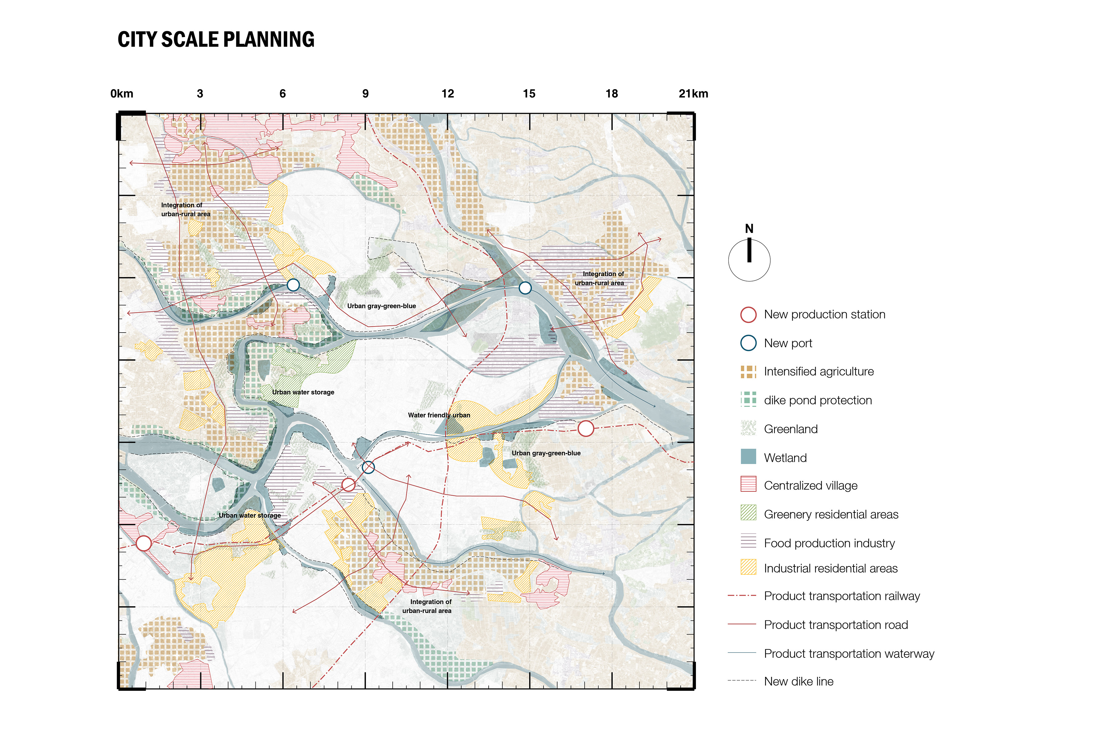
The tide can be turned in edge areas, where eco-common goods are threatened by dual burdens, through the introduction of new urban forms, good governance, and meaningful involvement. Urban forms will help to redistribute and produce resources through the redesigning land use, while good governance will introduce commoning that recognizes sensitivities, and finally, meaningful participation will provide a platform for hitherto silent vulnerable groups, and nature, to make their voices heard.

Based on the urgency of the crisis, centralizing rural areas and creating new wetlands at the mouth of the Delta will act as “stones” for a "ripple effect" in the functioning of the GBA ecosystem and could lead to the production, flow, and connection of ecological services. Over time, environmental justice will gradually emerge along the edges and spread like ripples of water throughout the whole GBA region, enhancing its resilience.


The Team

Christel Voncken 
My hometown in the water rich province of Zeeland. I got my first bachelor’s degree in Spatial Development at the University of Applied Sciences in Rotterdam, my second at the TU Delft for Architecture which was necessary to apply for my current Master Urbanism also at the TU Delft. My educational track helped me find my passion for urban design and exploring ecosystems, energising me every time I find something new.

Jingyi Chen
I come from Henan China and my bachelor major was landscape architecture. And I'm currently pursuing a master's degree in urbanism at TU Delft. Regional planning is, to me, the most important part of urban design. I would like to develop a deeper understanding of urbanism through the research on complex urban clusters like the Greater Bay Area, which gather economic development and climate issues.

Kelin Mu
I come from Shijiazhuang which located in North China Plain, so most things like flood and dike ponds in GBA are fresh and challenging for me. I started from learning plants in my bachelor in Beijing and continued with landscape in TU Delft. In this quarter I want to learn from broader scale, combine it with my bottom-up thinking method for multidisciplinary and multidimensional mind to design scientificly and humanisticly for people and nature.

Xinyi Wu
I'm from Wuhan China, I studied Architecture in my bachelor, and now doing my master of Urbanism. The reason I chose Urbanism is that I was so attracted by the research approaches like going through scales in urban design. Besides, I like communicating and working in groups. Being an urbanist means taking a lot of responsibility, that also means we can do more for a better world.

Xinyu Lin
I come from Sichuan province in southwestern China, a rich valley surrounded by mountains where I received my bachelor's degree of urban and rural planning in Sichuan University and am currently studying urbanism in TU Delft. I am interested in urban renewal and social justice in rapidly urbanizing areas and enjoy the process of analyzing complex problems in urban planning and design.


The Quest

Analysis of the unequal distribution of eco common goods

Unequal access to ecosystem services

“The urban landscape is a product of human interactions with nature. Cities constitute complex social-ecological systems, and the sustainability and resilience of cities is strongly related to the ecosystems and ecosystem services they provide.” 

(Unnikrishnan & Nagendra, 2015)

Analysis of environmental vulnerabilities

Lack of recognition of the Delta as backbone of commoning

“Most supporting and regulating ecosystem services, and some cultural and provisioning ecosystem services are declining because of a complex social trap, the “tragedy of ecosystem services,” which results in part from the overconsumption of common-pool resources.” 

(Lant et al, 2008)

Analysis of socio-economic vulnerabilities

The vulnerable who are left behind in the urban transitions

“With the rapid development of the social economy, remarkable demographic transitions have taken place in China in the past three decades. Approximately 250 million rural residents (40% of the whole rural population) move to urban areas each year, most of them are young and middle-aged migrant workers. Therefore, a large number of rural children, women, and elderly are left behind ”

(Luo et al., 2020)


The Challenge


What redesign of the dynamic edge areas can reintroduce the Pearl River Delta as a producer of common goods, thus increasing the accessibility and availability of its ecosystem services for the most vulnerable groups in order to achieve a more environmentally just Greater Bay Area?

What are the profiles of the most vulnerable groups, the population which carriers the socio-economic as well as the environmental vulnerabilities, and which ecosystem services of the Pearl River Delta can help them become more resilient?

How can the spatial restructuring of the dynamic edge areas increase their habitat for commoning for the vulnerable groups, while considering their social, economic and ecological sensitivities? And how can this restructuring support communing outside of the edge areas?


What planning measures can be implemented to protect the environmental justice within the Greater Bay Area the coming 50 years?
 

The Game

Exploring the edge conditions

The morphological game is a suited method to explore landscape systems to enable commoning. In our analysis we noticed that the edge areas are critical for creation of common goods. The first iteration of our gameboard was to identify the edge conditions within the Greater Bay Area and the landscape formations which shape them. This practice helped to recognise the two distinct landscapes of the Bay: the tidal area, formed by many edges and accommodates a lack of recognition for flooding protection, freshwater security, and the highland area, which has fewer edges and a declining recognition of food security and rainwater management systems.

Iteration process

Zipping and unzipping the edge

A concept sprouted from the two landscapes. The common goods they lacked could be provided by the other landscape. To change the edge conditions, we introduced the practice of zipping, integrating different land-uses, and unzipping, the introduction of a new land-use between to existing ones. In the following iterations the unzipping in the tidal landscape introduced industry, agriculture and wetlands for food production and flood buffer. In the highland edges zipping was predominantly applied to integrate green and water structures in the urban areas to increase infiltration and collection of rainwater against waterlogging and for refilling the reservoirs.

Rules and typologies of the gameboarding

Game findings

The gaming presented the possibilities in reforming the edges, but also the limitations. Redesigning the edge of the mouth of the bay can destroy existing habitats and would possibly affect the river trading routes and villages negatively. The edges are the lever for commoning and are sensitive for flipping the wrong way. Additionally, the edges aren’t continuous. They evolve through the landscape and accommodate unique systems, such as dike ponds. In our vision we need to be thorough in recognising these systematic sensitivities, attentive to the original, and design through scale and time to create sustainable edge conditions for commoning.

Final iteration
 

The Vision

Greater Bay Area Vision map
Four edge typologies

The Common Bay

To initiate the movement towards a more environmentally just Greater Bay Area, this vision poses a post-humanistic and socio-ecological approach, recognising silent stakeholders and the sensitivities of their communities and ecosystems. It aims to enhance the environmental justice by increasing the access and availability of common goods, starting at the most vulnerable communities who carry the socio-economic as well as the environmental vulnerability. These people groups who carry this double burden are left behind children, elderly, and migrants. The implementation of these small-scale actions will create a foundation of commoning for these groups and will possibly trigger a ripple effect amplifying the environmental justice in the whole Greater Bay Area.

Ensuring commoning in the Greater Bay Area, means acknowledging the greatest provider of ecosystem services as common entity, the Pearl River Delta. The services and resources that directly support human health and live fulfil the first needs of the population while guarantee a solid groundwork for recognition of the delta by integrating its ecological systems in the megaregion design. These ‘eco common goods’ are food and freshwater security, flood and waterlogging prevention and ecological underpinning.

The dynamic edge areas in the deltaic landscape are the leverage of the provision of eco common goods and accommodate many communities with carrying the double burden. By redistributing the land-use in these areas based on the two distinct landscapes of the bay, tidal and highland, and the local sensitivities, the increasing exclusivity of the eco common goods will pivot. These lower-scale systematic changes will evolve into a regional symbiosis between the landscapes, the tidal landscape providing food security and flood prevention, and the highland landscape will ensure fresh water and lessen waterlogging. The underpinning of this symbiosis and the resilience of these commoning systems are warranted by an ecological framework crossing all scales.

To systemically realise this vision all actions are based on three principles: RESTORE local socio-ecological systems while being aware of their sensitivities and traditions, RECOGNISE the ecosystem services as common goods by integrating them through the different scales in the community and governance, and ROBUSTNESS by designing adaptable and dual functionality. The recognition of the Pearl River Delta as common entity will be established through urban form, good governance, and meaningful involvement. This approach and the principles will turn the Greater Bay to the Common Bay, supporting a just and resilient future for the megaregion, while leaving room for adaptability within the course of action.

Strategic aims

Strategic aims through scales

Each scale harbours different elements for the creation of common goods, for example the river body on regional scale and the waterworks on city scale. Thus, demanding a systematic approach for the strategic aims to connect them to the multi-scalar character of commoning. For the Greater Bay Area the strategic aims stay conceptual but are steering principles for the development of the region. Restore, recognise and robustness induce the acknowledgement of the Pearl River Delta, awareness of the constant evolving of our ecosystems and the identification of silent stakeholder and ecological cycles. Typologies and roles of environments are introduced in the city scale. For the initiation of change, the land-use typologies enable future city development patterns reforming the relations between the edges and landscapes. The redistribution of land-use takes place in the district scale enabling the edge conditions to enhance their reproduction of eco common goods.

Strategic aims in time

A step-by-step approach

To adapt or restore socio-ecological systems, time is key. However, time also does not stop and the decline of eco common goods maintains if there is no change. Therefore, the first step is to establish a Safe Living Environment. By condensing the emptying urban areas in the tidal landscape, space is made for agriculture and floodplain which increase the accessibility of food, infiltration of rainwater and flood protection. This is partially combined and followed by the second step for Health Habitats. By restoring and intertwining wetlands and mangroves with the edges of the tidal landscape, the ecological underpinning of eco common goods in the Greater Bay Area will be strengthened and the effectiveness of farming practices will be maintained or even enhanced by healthier soil, water and fauna. In the third step Evolutionary Economy, the Bay’s farming, trading and production areas will be integrated with other functions to create more resilience through diversification and interrelations. During this phase, the last step of Great Living Environments is initiated. In the tidal as well as the highland areas, the urbanisation gets integrated with green and blue structures to limit waterlogging and increases the collection of rainwater for a resilient watercycle. Not only will the implementation of greenery help with the water problems, it will also help against heat island effect and improve the living quality of the Greater Bay Area.

Timeline governance and meaningful involvement

Good governance and meaningful involvement

The groundwork to protect the eco common goods in time and scale is the incorporation of good governance and meaningful involvement of all stakeholders. Multi-scalar governance can protect ecological structures through policies and can empower vulnerable stakeholders by participation. Meaningful involvement is necessary to form suited policies and fit empowering tools. It is centralised around recognising and awareness of sensitivities and characteristic of communities and ecosystems. This involvement is currently not well incorporated in the multiple governance structures; thus this vision calls out for a new civil sector representing the silent stakeholders: nature, vulnerable people groups and future generations.

Strategy in city scale

Systemic approach through scales
We implement the principles across different scales, ranging from the mega region to the neighbourhood level. Our goal is to facilitate the delta in generating ecosystem services. Through identifying various and diverse edges, we highlight the cycles of ecosystem services and the commoning process at the city level. As we zoom in to the district level, we demonstrate the network of eco common goods and their distribution between private and public spaces. At the smallest scale, we prioritize spatial quality, emphasizing the creation of eco common goods and their interaction with people.
 
Analysis current situation of Shunde

Residents in the Shunde area are facing several key issues that contribute to a low quality of life. The infrastructure is relatively outdated, with problems such as traffic congestion and unstable water and power supply. Additionally, there is a lack of resources in education, healthcare, and social services, which hampers the educational attainment and overall health of the residents. The aging population is also becoming a pressing concern, as the health, social, and caregiving needs of the elderly are increasing. The social welfare and eldercare service systems are relatively inadequate, posing difficulties for the elderly in their daily lives.

With urban expansion, many traditional dike areas in Shunde are at risk of being developed and transformed. The absence of adequate protection of traditional culture and the natural environment in urban planning has led to the disappearance or destruction of these traditional dikes. Consequently, valuable resources connecting to history and tradition are being lost.

Conclusion map of the urgency within Shunde

The traditional dike industries in the Shunde area are facing decline. Traditional sectors like fishing, agriculture, and handicrafts have been negatively impacted by decreased market competitiveness and a shift in employment preferences among the younger generation, leading to developmental challenges. This decline results in the gradual disappearance of traditional skills and culture, adversely affecting the local economy and society.

Furthermore, the presence of rivers and extensive agricultural activities in Shunde makes it vulnerable to environmental disasters. Issues such as water pollution, declining soil quality, and natural disasters pose risks to both the environment and human well-being. Inadequate environmental management and protection mechanisms hinder effective solutions to environmental problems.

Conceptual conclusion map

From overlapping the problems, we have concluded that this area is in lack of the following eco common goods: flood protection, water management systems, healthy living environment and ecological structures. We want to intensify the agriculture production and urbanisation, accelerate the industry transition and increase the food production, also add greenery to prevent flood.

Vision Shunde

Based on the strategic map and city-scale planning, we can observe a landscape transformation that leverages existing infrastructure. The key features include the establishment of networks connecting new production stations and a new port, which serve as a backbone for development. Additionally, we have intensified agriculture and centralized villages, while creating wetlands to enhance water absorption and protect the surrounding villages. Furthermore, the development of a new local food industry has been prioritized to enhance food security.

Vision eco common goods cycle Shunde

At the city scale level, our design strategy can be summarized into three main directions: resilient flood prevention measures, rainwater management, and green optimization within the city, and the integration of agricultural production areas with industrial zones, involving industrial transformation. These three directions support the structures which create eco common goods.

By constructing aquatic habitats, enhancing ground permeability, and establishing wastewater collection and purification systems (including natural water bodies and water treatment plants), we aim to provide more freshwater resources. The wastewater generated within the city, factory effluents, and flood-related sewage can all be reused through this approach.

In the industrial areas, more roads will be constructed, ports will be developed along the river areas, and product distribution routes will be increased within the towns. This will facilitate better circulation of food resources and promote the sharing of other products. Within the city, a significant emphasis will be placed on increasing green spaces, an important natural element, to provide better living environments for the elderly and children.

Strategic approach of good governance

Cross-scale governance

Just like the spatial endeavours, the management and governance of these actions takes between sectors and through scales. To realise and maintain the provision of eco common goods the alignment of interests within the governance entities is a necessity. The practice which makes this possible is roundtable discussions. The table facilitates creation of collaborations, coordination, and decision-making between the government bodies. To put this vision into play, three tables of governance bodies need to have cross interaction and establish cooperation: the multi-scalar public sector, the diverse environmental sector, and the coordinators of the different cities. Just as the vision, this cooperation will the support the public through an environmental lens while crossing city and landscape borders.

Implementation on district scale

Location district scale interventions

Building upon the medium-scale planning foundation, we have chosen these three areas as small-scale design examples. Area one primarily encompasses industrial zones in need of transformation, extensive farmland, and with a significant population of farmers and fishermen. Our objective here is to facilitate industrial transformation. Area two consists mainly of aging residential areas and delta regions prone to flooding, posing a threat to vulnerable populations such as the elderly and children. We aim to optimize the environment and create a resilient floodplain by incorporating more green and wetland spaces. Area three represents the inner city region, characterized by numerous hardened areas, industrial zones, and low-cost housing. The primary demographic in this area is young migrant workers.

Vision area 1: Food

Area one is highly industrialized and hardened with poor resistance to flooding and heavy rainfall. The residential areas are influenced by industrial areas in which migrants are lacking in good living and working conditions. In addition, the dike ponds with which it intersects the area needs to be protected.

Our goal is: rain and flood resistant green industrial and residential areas. Therefore, we remove the industrial buildings along the river, introduce wetlands into the riverbank and green areas, transform the existing river into a flood-resistant green public place, and introduce a green stormwater management street system into the industrial area, strengthen the green residential area, and restore the dike pond.

Vision area 2: Living quality

Area two is located at the confluence of rivers. Existing out of mostly villages and dike ponds, where the elderly and children left behind are exposed to flood hazards and lack adequate living resources and facilities.

As a counter response, wetlands were introduced and existing waterways were transformed into green spaces with flood control functions. The rearrangement increased the connection of the area to external and internal social services serving the elderly and children.

Transformation of the residential area into a green integrated area. Tourism functions are added to the dike pond to create employment opportunities and attract migrants back to their hometown for employment.

Vision area 3: Flood&water logging

Area three is a complex intersection of urban and rural areas, farmland, industry, rivers, and forests. There is a need to curb urban sprawl and flooding encroaching on valuable traditional dike ponds, while considering how to help farmers and fishermen sustain their livelihoods.

To initiate, wetlands and floodplains get introduced to the riverbank to provide ecological and flood control values and as public space.

Secondly the traditional dike pond production get revitalised, by returning some of the land eroded by factories, introducing green rainwater management systems into industrial areas, and transforming factories into new green agricultural industries to provide better income and employment opportunities for farmers and fishermen. In addition, to preserve the different atmosphere of urban settlements and rural settlements and to promote their integration with natural areas.

GBA vision 2030

GBA vision beyond 2030

A ripple to turn the tide

In the face of the three transitions, climate change, industrial transition and the demographic shift, the current Greater Bay Area will only get more socio-economic and environmental vulnerabilities due to the increasing exclusivity of the ecosystem services.


The common bay vision will turn this tide by recognising the Pearl River Delta as the backbone of a just Greater Bay Area through redesigning the landscapes edges and by small-scale endeavours increasing the commoning in the most vulnerable communities. The creation of this foundation for communities and the delta ecosystem will initiate a wave of the environmental justice within the Greater Bay Area, enhancing resilience while ensuring the protection of eco common goods and space for future planning adaptability.


Common goods, Environmental justice, Socio-ecological systems