Diasynchronic Identity


Manifesto

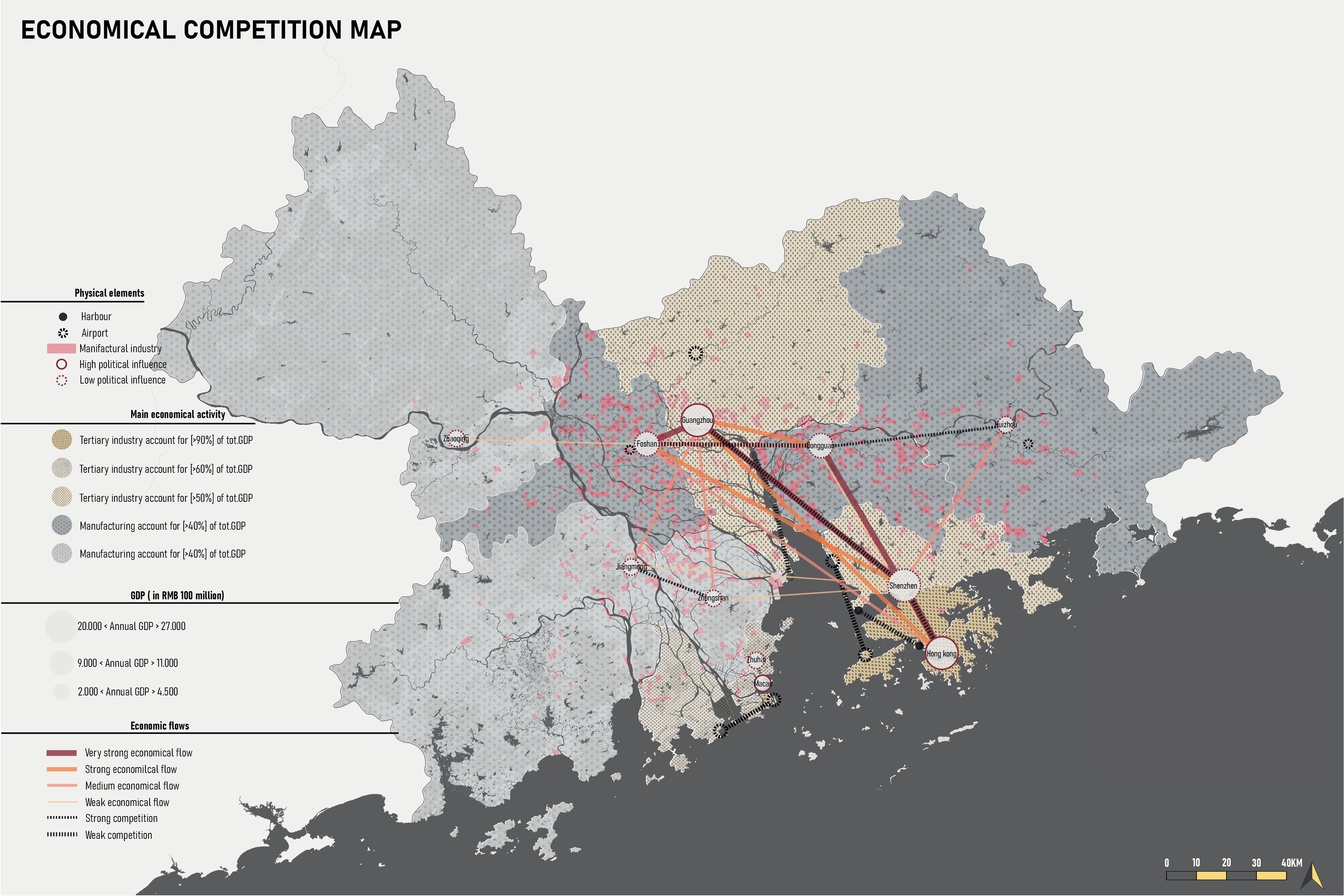
In the past 40 years, the Greater Bay Area experienced the effects of fast urbanisation and industrialisation. Together with this abrupt change, from a rural-based economy to a strongly industrialized one, the difficult political situation in the Delta has led to the formation of a pluricentric model where the different cities race against each other to take the leading position, speaking both economically and in terms of power of decision making.

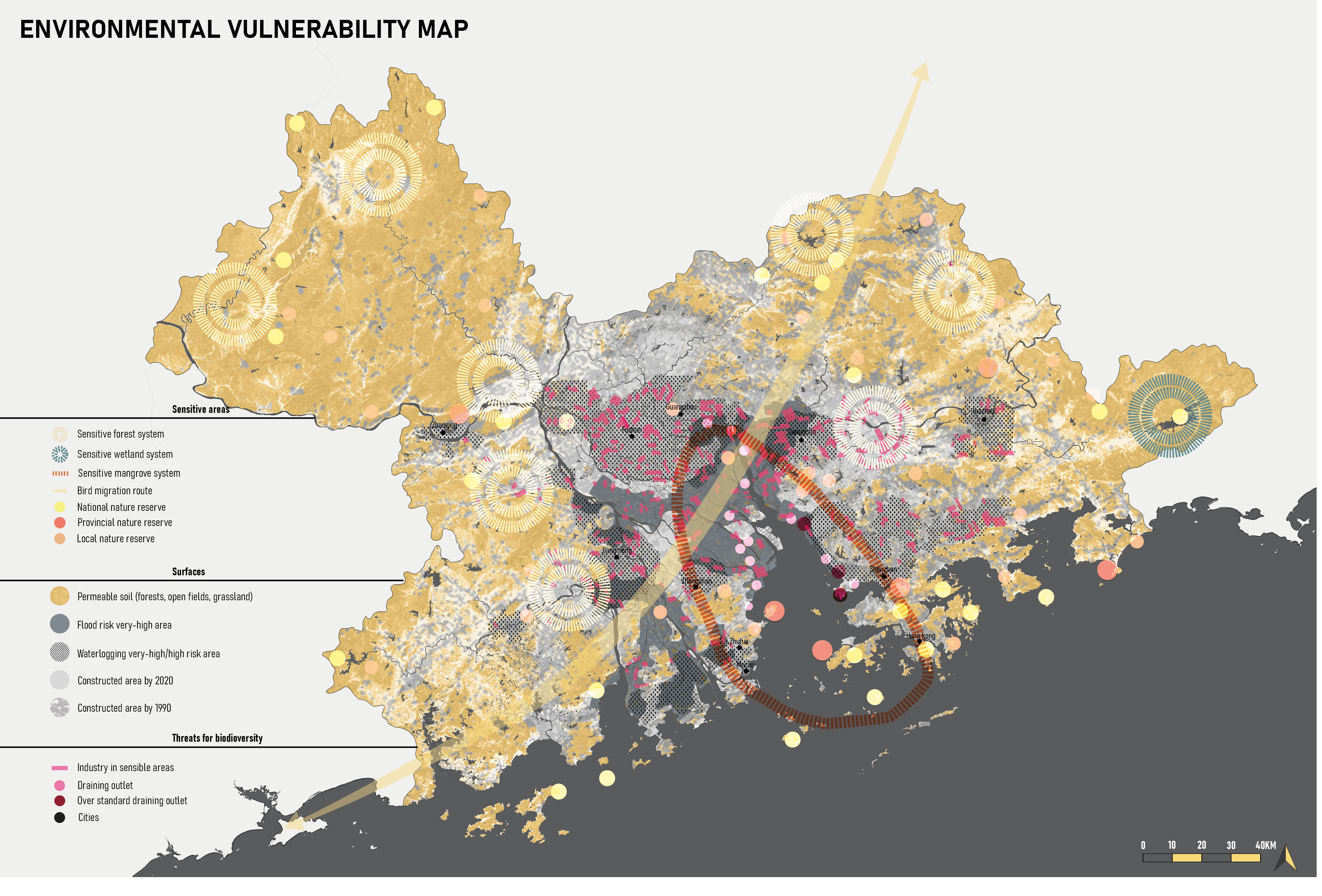
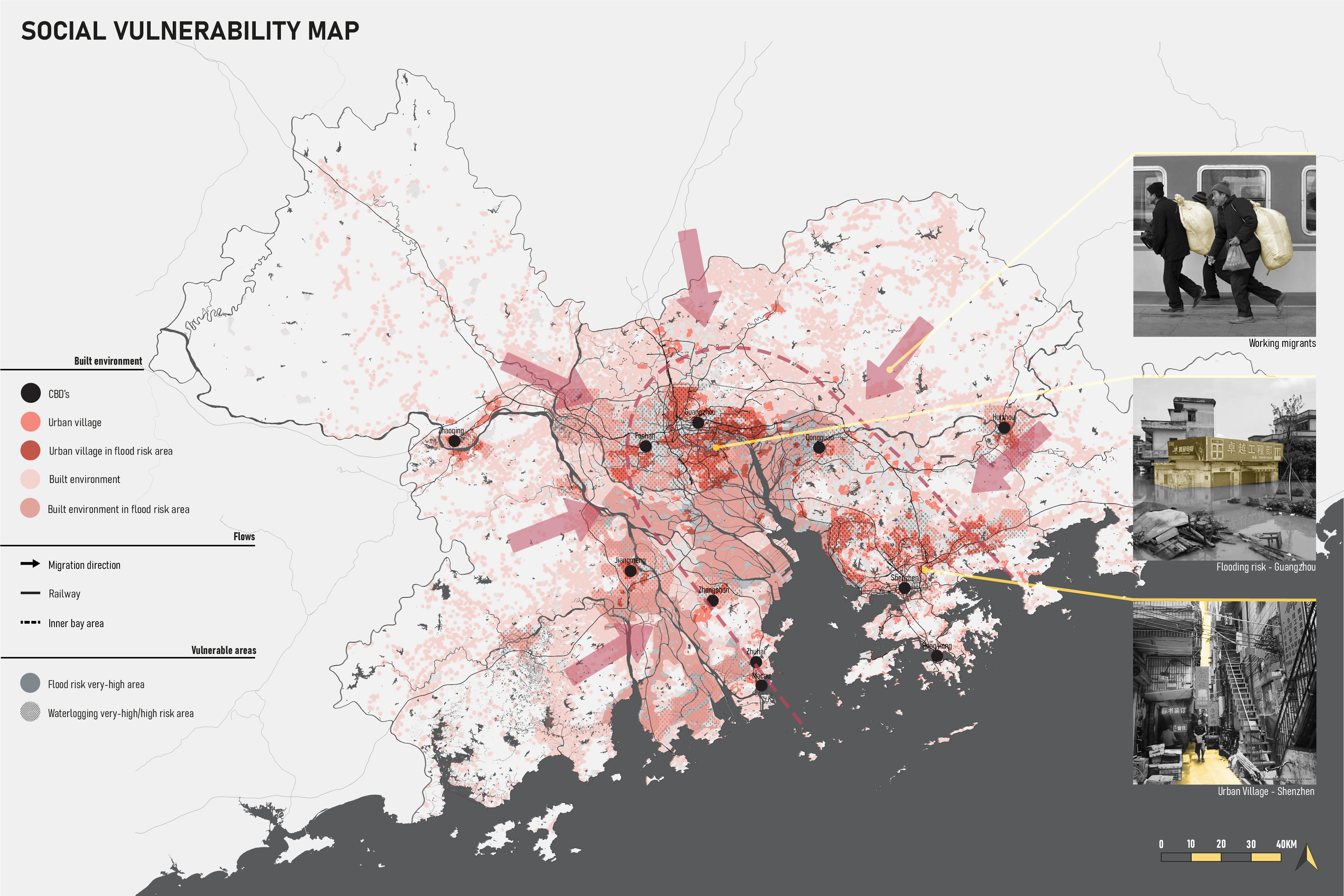
The highest price in this race for power is paid by less influential and voiceless stakeholders, since economically driven development plans have led to a deployment of natural and human resources, making the present GBA ecologically and socially fragile and vulnerable. In this climate of excessive competition between the cities in the GBA, it becomes complicated to imagine the development of a polycentric city-region, as the different components are afraid of being absorbed and losing their leading market position along with their importance on the global scale, while its residents struggle to feel as if they belong.

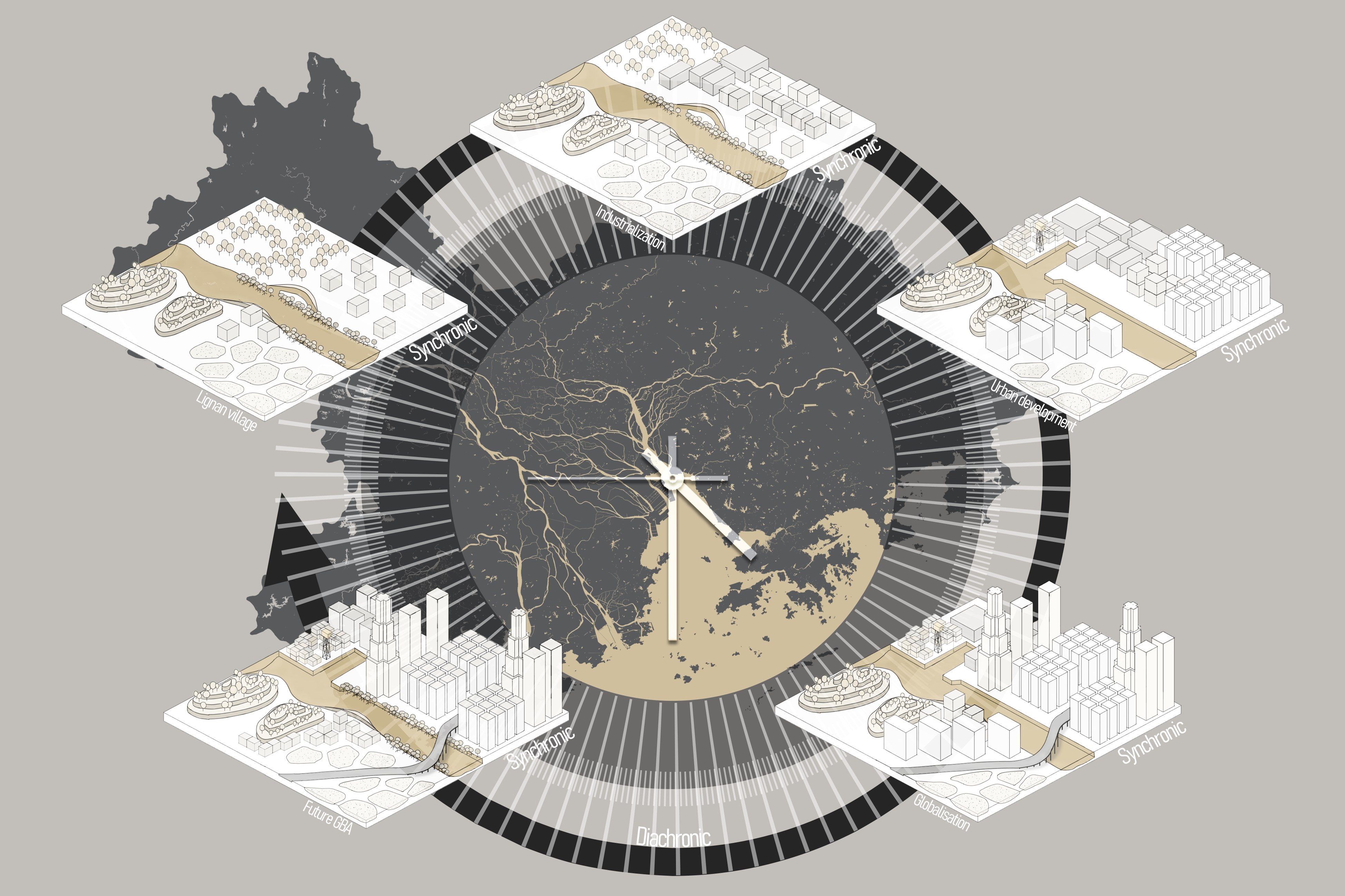
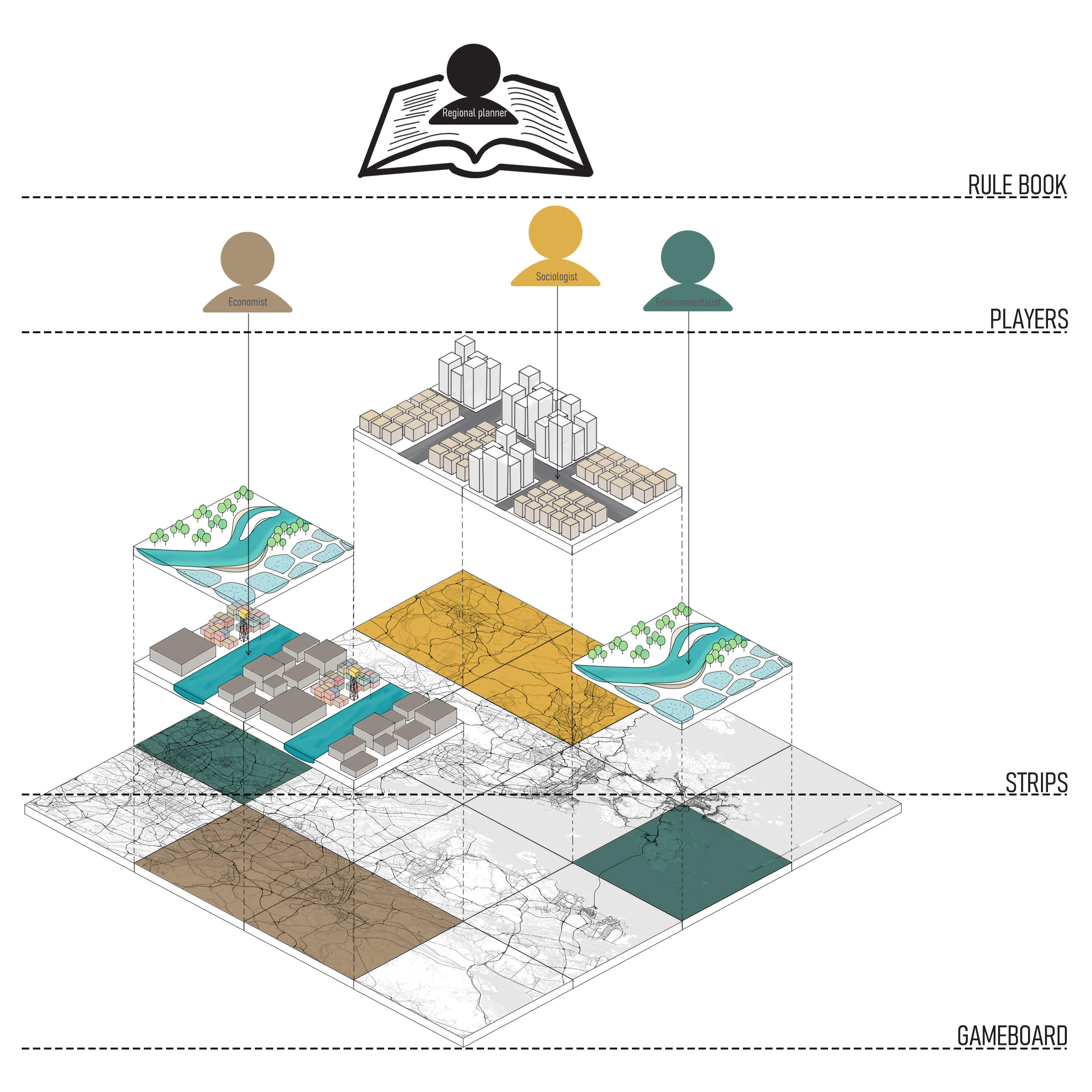
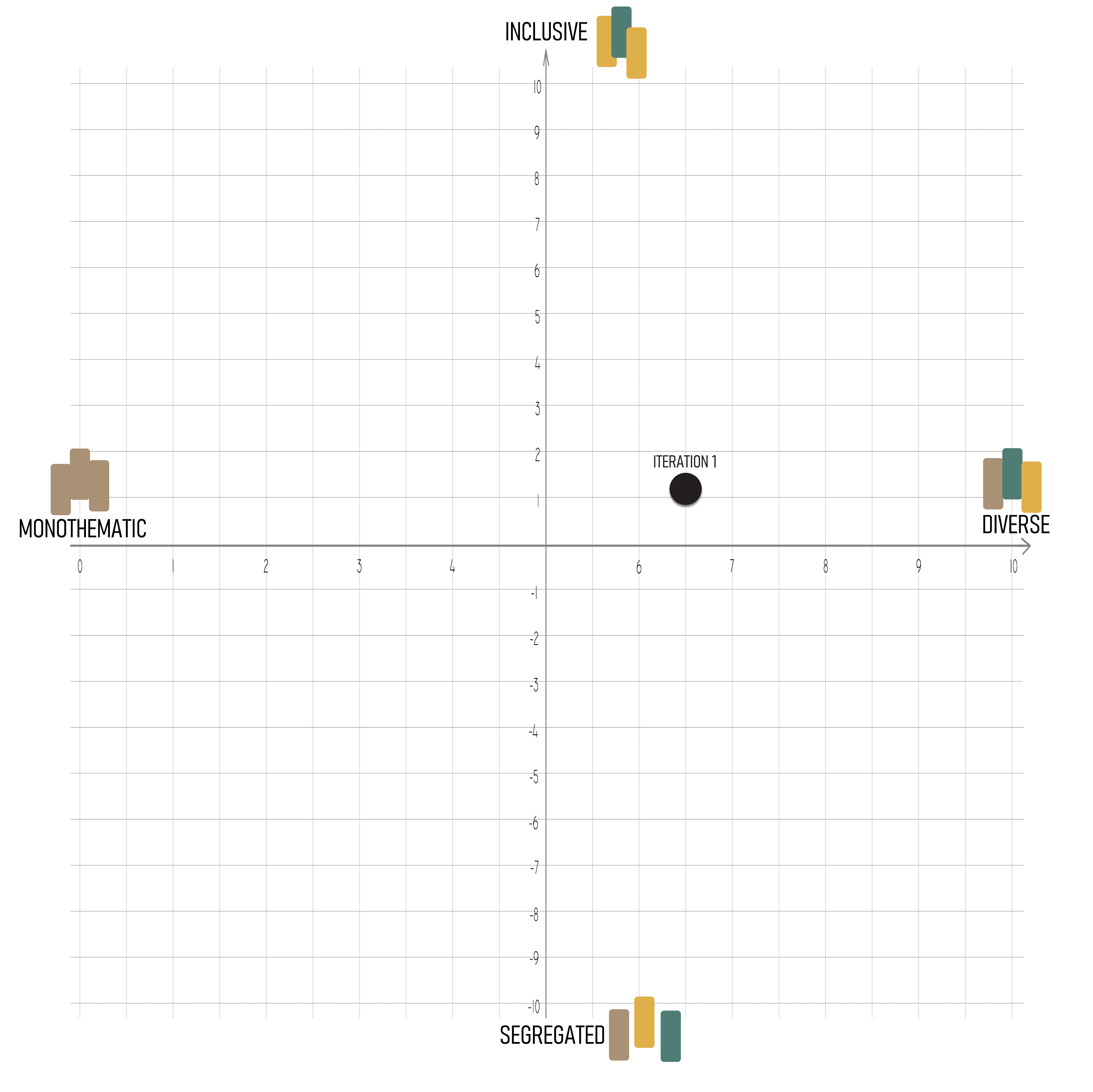
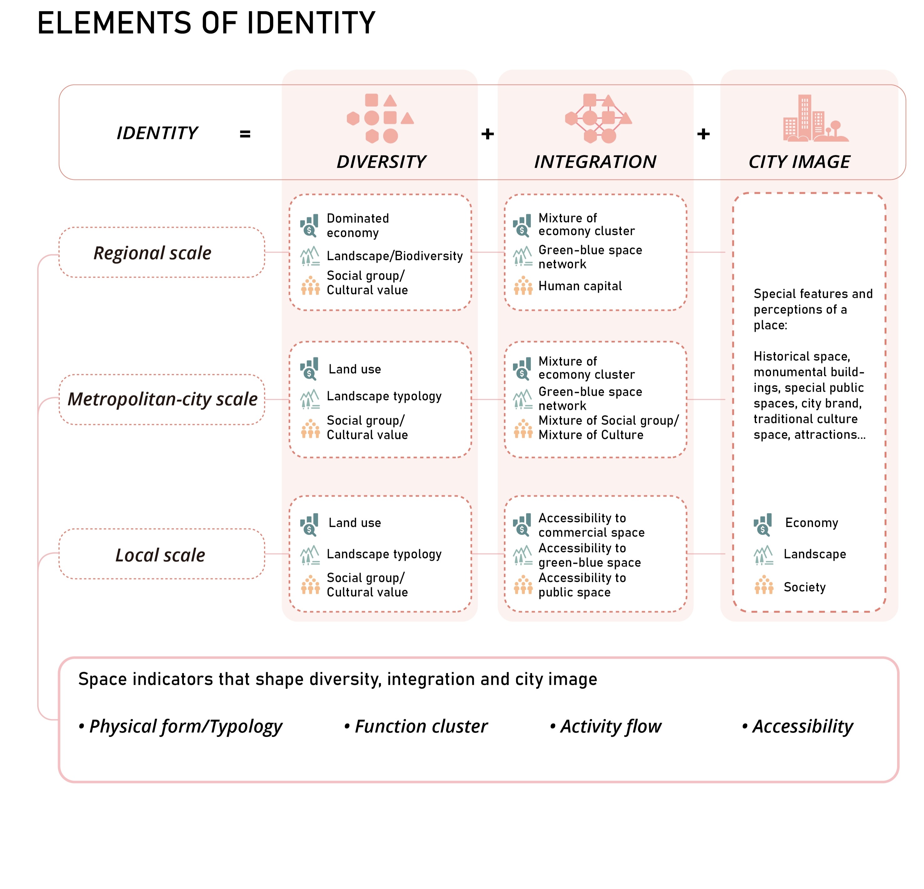
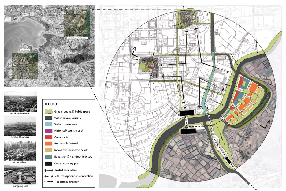
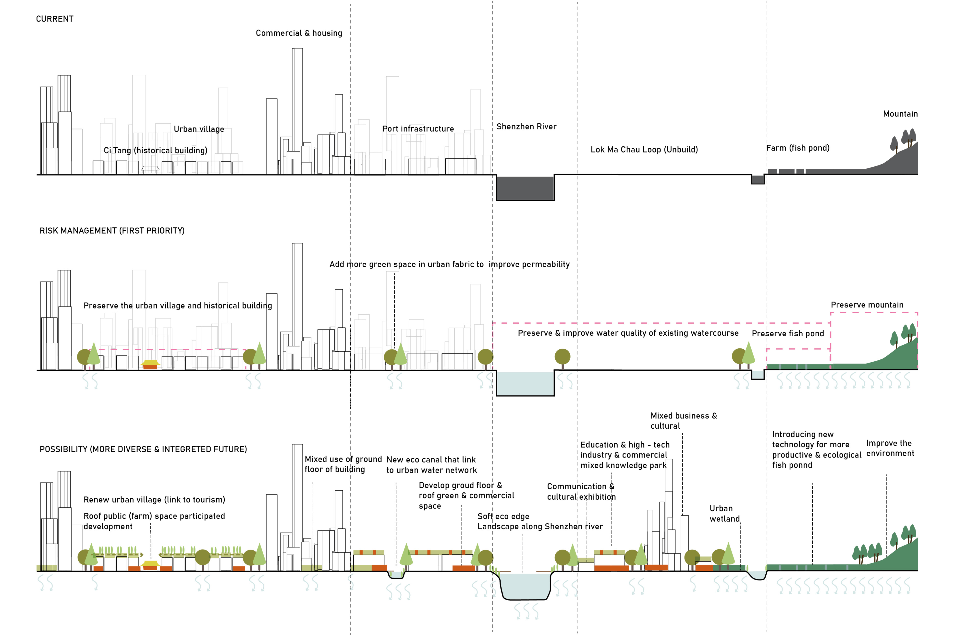
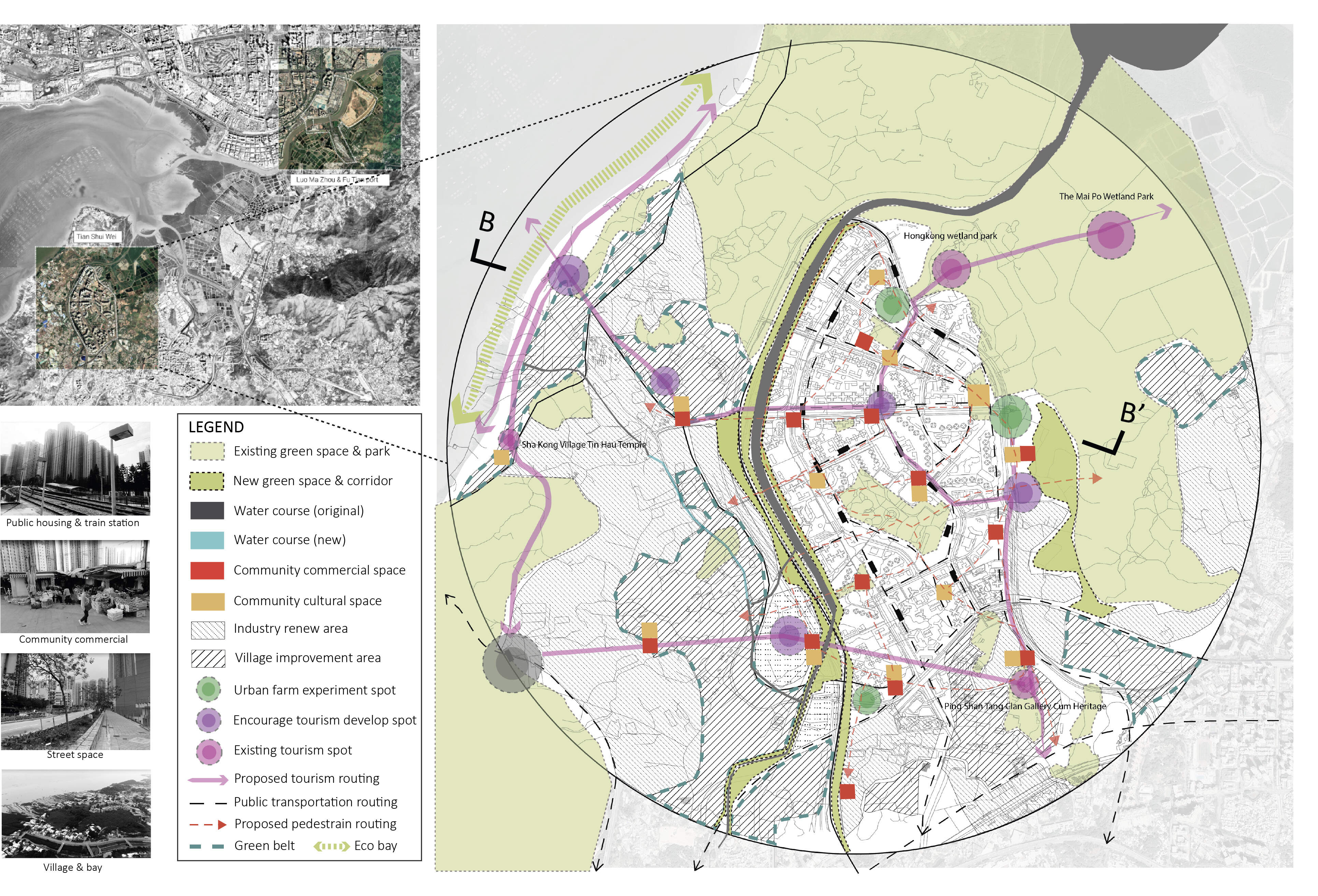
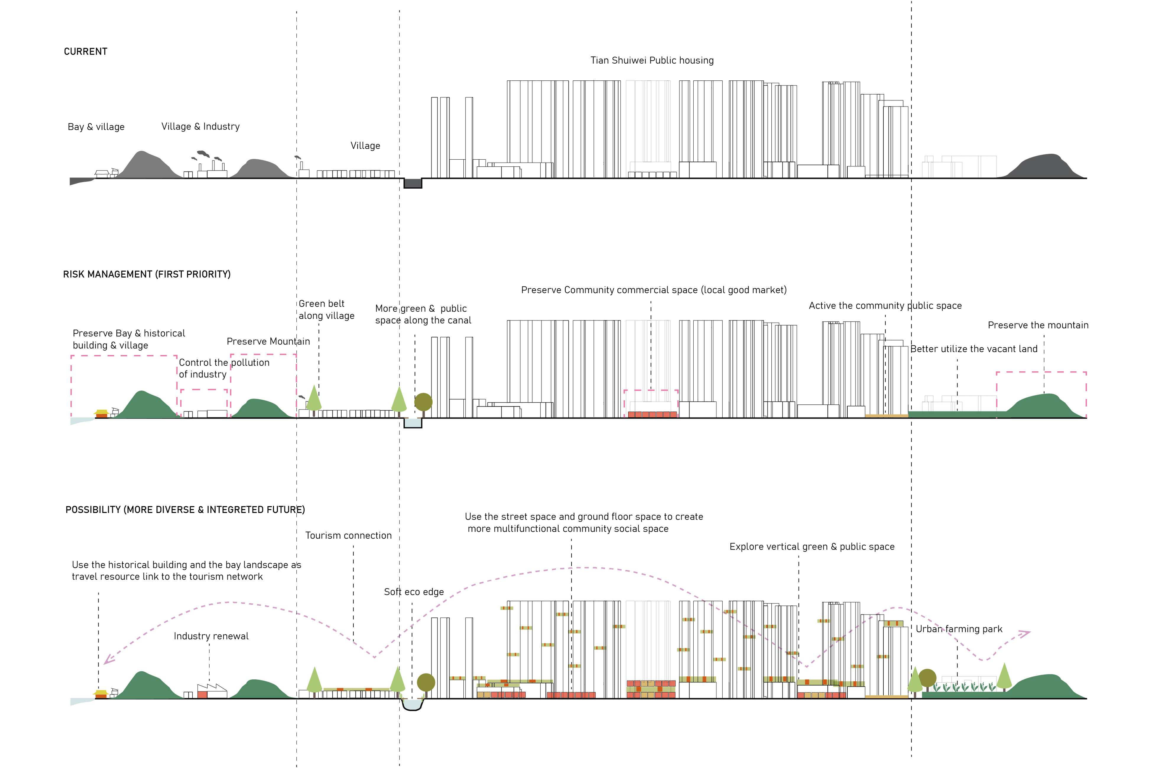
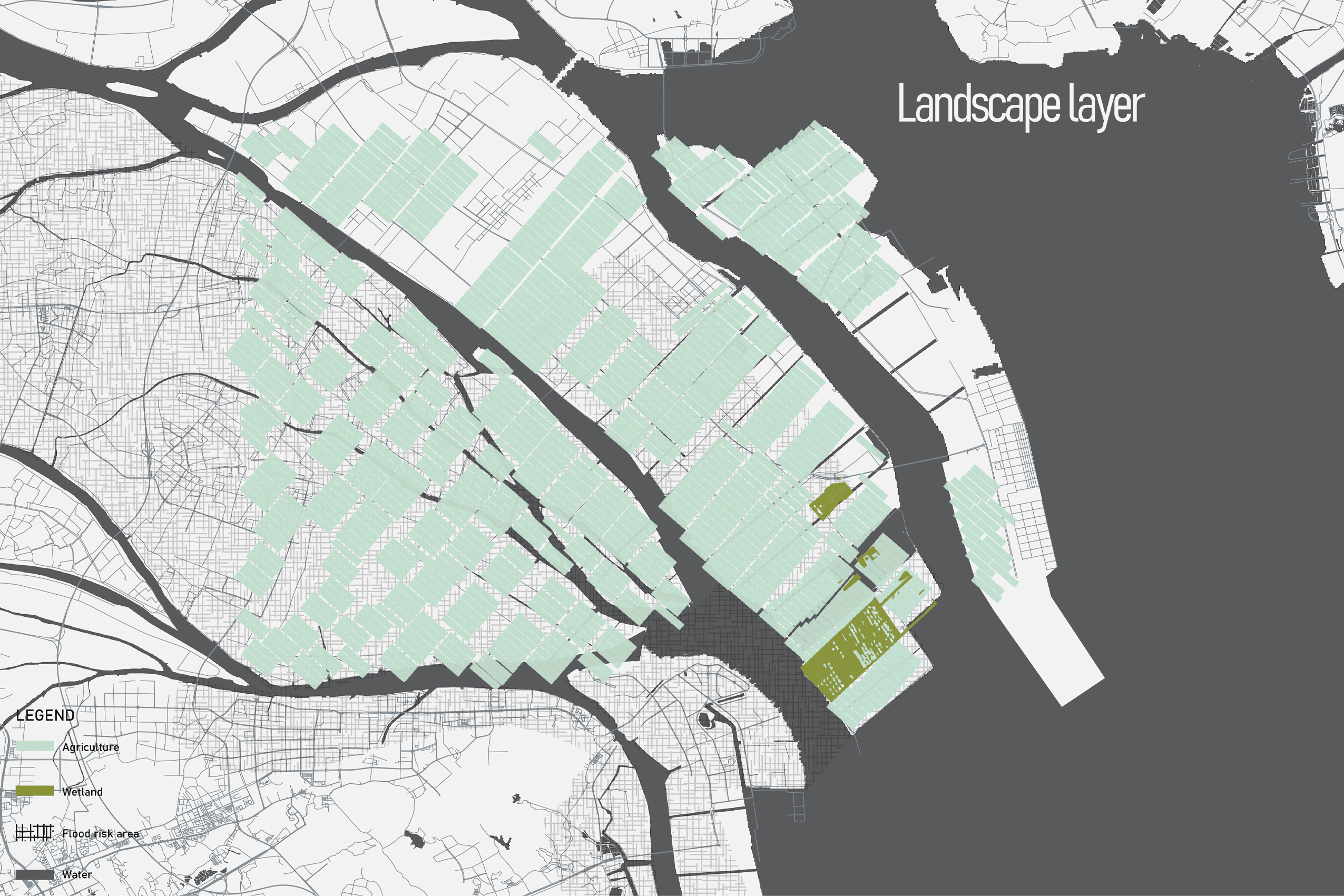
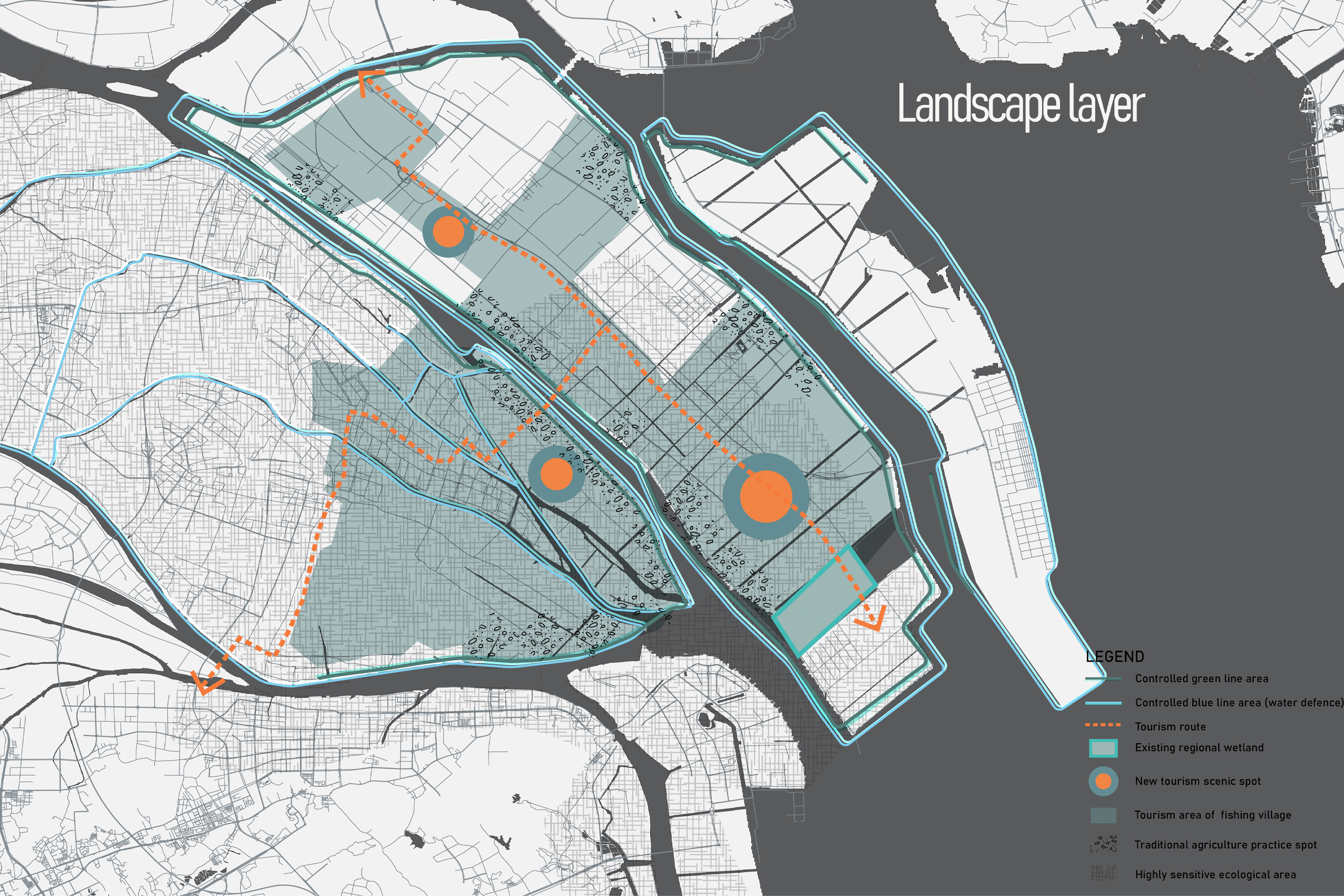
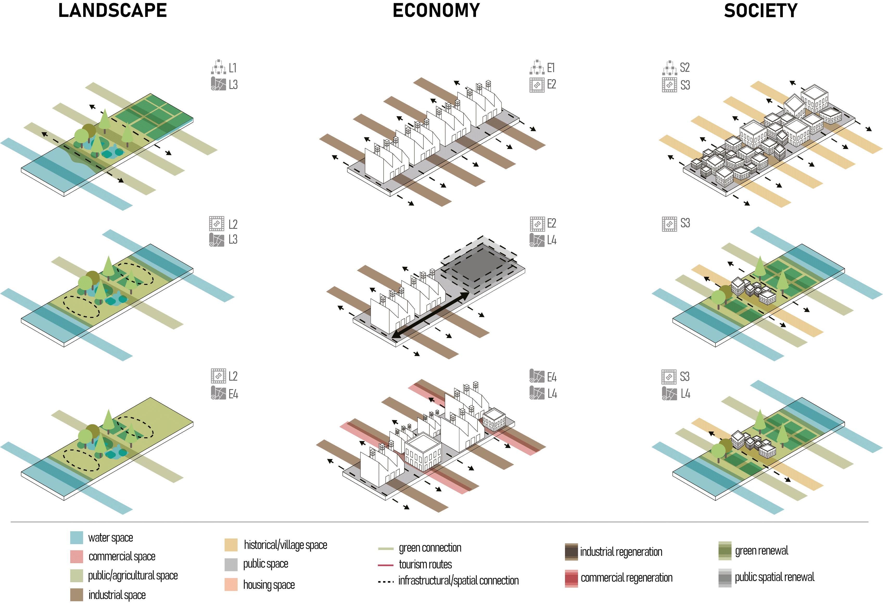
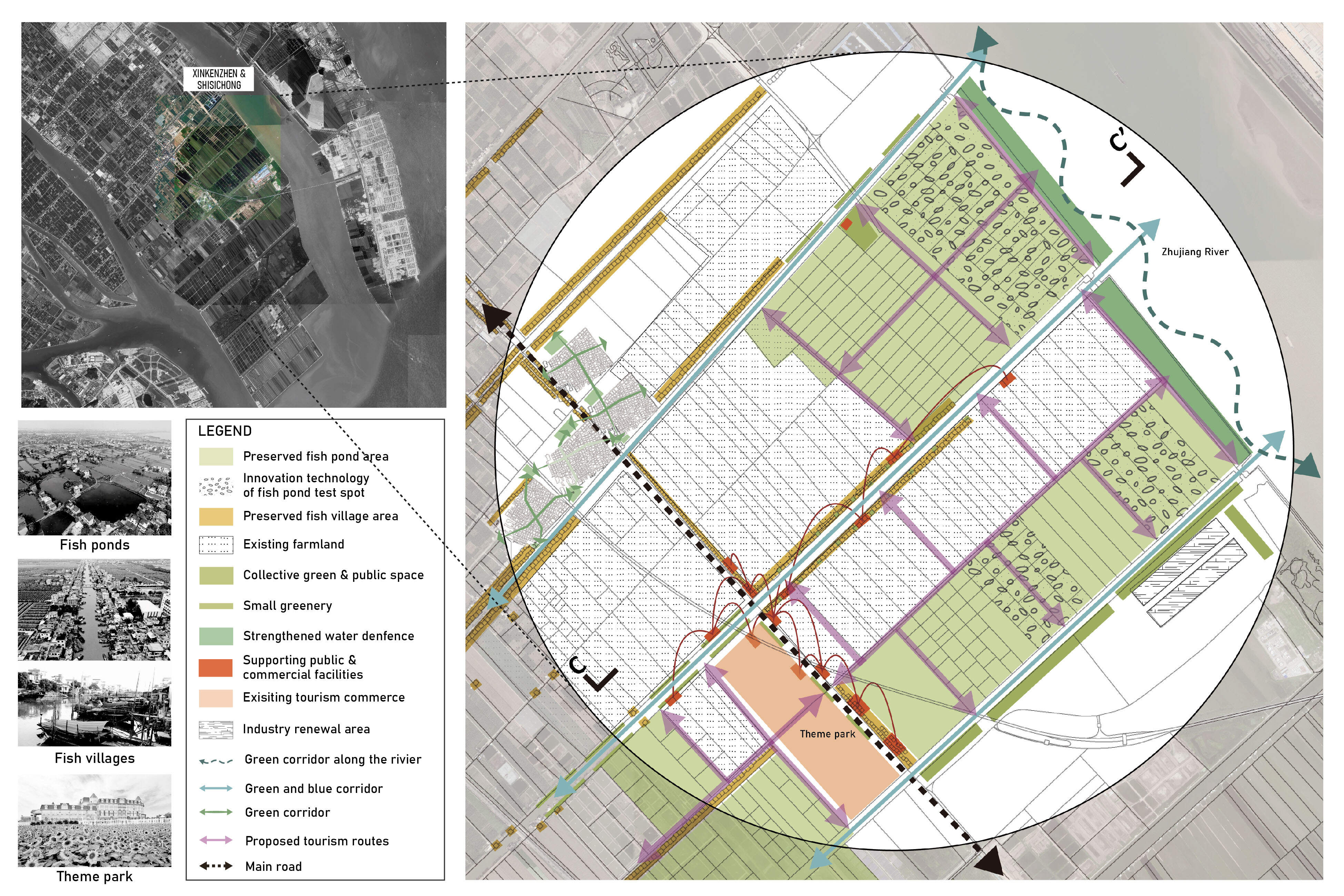
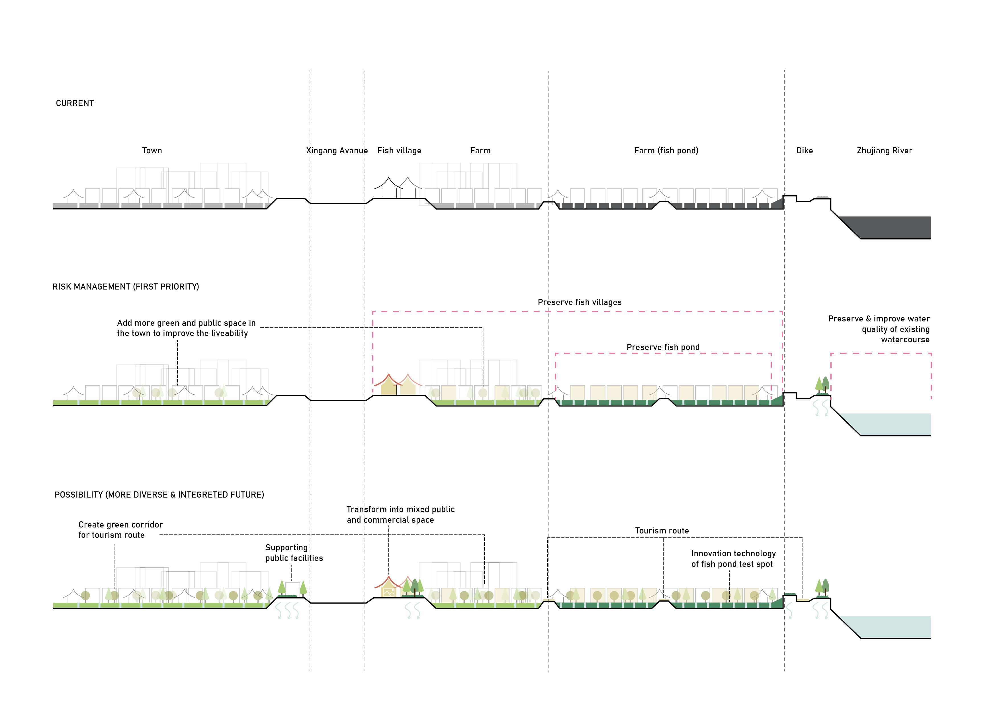
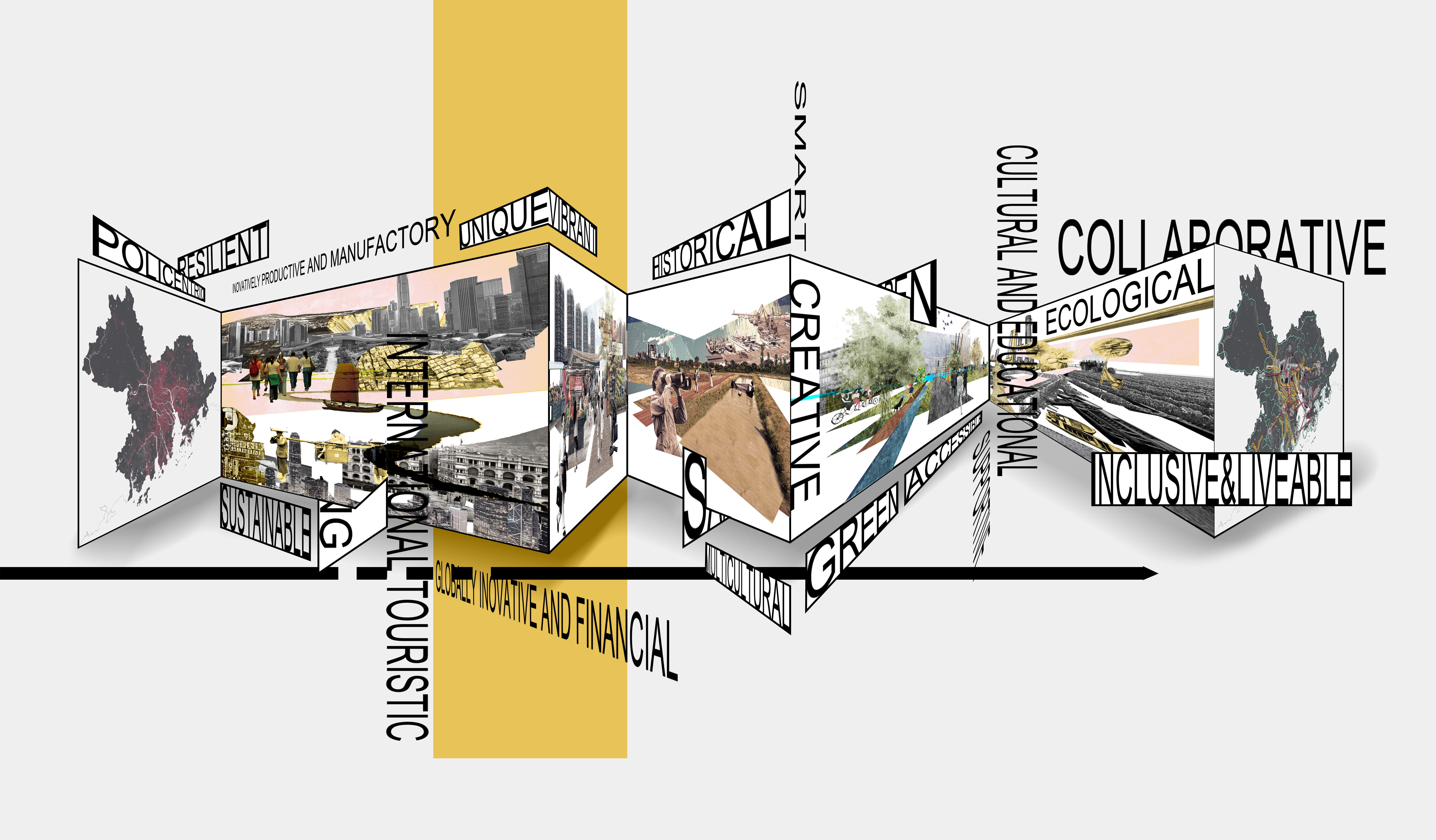
All this can be translated as a fear of losing identity, both spatially and socially. The aim of this project is to propose strategic planning guidelines and interventions that are able to break down the wheel of excessive competition between different, equally important parts of the GBA and build up a stronger regional identity, starting from the conservation and support of the different existing city identities in the Delta region in order to facilitate collaboration for future regional policies that improve the qualities of the polycentric model. Hence, it is fundamental to understand what the word identity means, what approach has been chosen to study it, what its main components are, and how it changes through time and not less importantly through scale.


The Team

Nadya Chabayeuski 

was born and raised in Minsk, Belarus and obtained her BSc in Architecture, Urbanism and Building Sciences at TU Eindhoven. She is now completing her MSc in Urbanism at TU Delft, with her current topic of interest being the relation of regional policies and strategies to the socio-spatial context of lower-scale urbanised environments.

Patrick Tobias Maurer

born in Germany and grown up in Tuscany (Italy), holds a bachelor degree in Landscape and Urban planning obtained at the University of Florence and studies now at TU Delft, master degree in Urbanism. Has a love/hate relationship with regional planning.

Pingyao Sun is a Chinese student who obtained both a Bachelor’s and a Master’s degree in Urban Planning. After a period of working as an urban planner, she decided to further broaden her knowledge and is now completing her MSc in Landscape Architecture at TU Delft. She is most interested in the topics of social gentrification, community participation and ecological preservation.

Keyan Tang

is born in China, holds a bachelor degree in Landscape Architecture at Tianjin University in China and now studying Landscape Architecture at TU Delft. Has a great love with local design and skilled with small scale designing.

Bowen Yuan is a Chinese student who obtained her Bachelor of Architecture at Wuhan University. She is currently studying Urbanism at TU Delft and her interests lie in social justice, urban renewal, and governance. By participating in this studio, she hopes to deepen her understanding of GBA context and regional planning.


The Quest

Economical competition

“As many parts of the mainland PRD will choose to become less manufacturing and more service-oriented, it remains to be seen how global city Hong Kong will be able to maintain its competitive position within the global city-region GPRD...It has been argued that bottom-up economic integration of the GPRD is no longer sufficient to face the competition with the less poly-nuclear Yangtze River Delta, which has attracted more FDI in the past decade and where GDP growth has been considerably higher than in the GPRD”
(Jiangbo Bie, Martin de Jong & Ben Derudder (2015) 

Ecological vulnerability

“Anthropological impacts are not only causing a loss in biodiversity but are also disrupting the ecological functions of freshwater ecosystems. The major direct threats identified include flow alternations, habitat change and degradation, and pollution...The misuse and overexploitation of the freshwater environment and resources are having a real impact on the availability of fresh water for human and industrial consumption, with social and economic consequences."
Leung Sze-lun, Alan Chung Hoi-yan Tong Xiaoli (2007)

Social Vulnerability

"Social identity defines how people perceive themselves based on their group membership. Similar place, religion, and ethnicity can play an important role in shaping community membership and perception of self. Indeed, the physical environment has a significant influence on social identity"

Urbanization and Urban Villages: Institutional Factors and Social Identity in Urban China (2015)

"Migrant agricultural population and urban residents regard each other as "the other", which is difficult to form integration, and there is a threshold in identity. Such segregation of social rights and identity constantly shapes two mutually separated social Spaces, resulting in social inequality and a high degree of social differentiation, and creating a "dual society" in a sense inside the city"

Segregation of "village in city" from the perspective of social space (2015)


The Challenge

What are the elements that compose a regional identity and which factors make them spatially measurable?

How could a stronger spatial identity positively affect the collaboration and creation of a polycentric city region in the GBA?

What strategies can be adapted to solve the problem of excessive competition and loss of identity? How do they differ according to the scale of intervention?


The Game

Morphological game principles

How to play: The developed strip game is a morphological game that can be used to explore large scale strategies; it is a useful tool to observe how the goals and strategies of different players involved in the game change when various iterations are played. The iterations are diversified by the restrictions and guidelines that the regional planner sets up in the rulebook. To play the strip game four things are needed:

  • Gameboard: a defined area, in this specific case the GBA;

  • Typology of strips: each strip represents a different land use determined by the colour of the strip;

  • Players: which can be characterised by non-physical entities (as landscape, economy and society) or physical entities (as stakeholders) depending on the topic of the game;

  • Rulebook: written by the game master, in this case, the regional planner, it has the task to set limitations and guidelines.

The assessment method

The assessment method: Each iteration is then observed by the game master after it has been played to calculate its effective values of integration and diversity, the two indicators of identity. By quantifying the two indicators it is possible to evaluate if an iteration has a positive outcome or not, compared to the current situation of the GBA, which helps the planner to make different conclusions on:

  • Which of the iterations is the most likely to be adopted in a vision for a stronger regional identity;

  • What are the different goals of the stakeholders and how are they trying to achieve them besides the main goal of preventing the progressive loss of identity;

  • Which are the most neglected areas of the GBA in terms of integration and diversity, both before and after the iterations.

Iteration 1/4- The free to play version

The free to play version The first round consists of putting all the strips that describe the current situation on the playground; in this case, the strips are played mainly by colour and not by importance as they describe the status quo. The game master has the task to decide which orientation the strips will have (vertical, horizontal or diagonal), mainly following the pattern readable from the base map. Each player will have the opportunity to play one round as a leading player, meaning that they can start the turn and the other players have to adapt to their move.

  1. Player A can play as many strips as they need

  2. Player B and C have to use a lower amount of strips compared to player A

  3. Player B and C cannot put strips over the strips that player A disposed of on the field

These iterations are played in order to define the different goals and actions each player would have in a non-competitive environment.

Iteration 6 - Development limitations version

Development limitations version In this iteration the regional planner sets a limit of usable strips for all the players involved. Then, the players themselves must define 3 main goals and a non-negotiable principle before they start playing. Each of the players has to play three turns, in each turn they will try to achieve one of their goals without exceeding the number of strips given. The order of goals can be decided by the player. This iteration is played in order to discover possible incompatibilities between the goals of one player and the non-negotiable principle of another.

Iteration 7 - Flood risk version

Flood risk version: In this case, it is the regional planner that plays a non-negotiable principle by giving stronger restriction measures to the areas that have a high risk of flooding or waterlogging. The players then play according to the given restrictions while also trying to follow their interests at the same time. This iteration provides a good insight on how a strategy could be developed more realistically, with concrete threats and challenges, allowing us to predict how the ways of reaching the goals of various stakeholders will play out under specific restrictions.


The Vision

Diverse and Integrated GBA

It is impossible to make certain predictions on how the identity of the GBA will change over the next few years as it is a very abstract and philosophical concept. That is why the vision for a diverse and integrated GBA does not pretend to form a new regional identity but aims to create the right conditions by using the tools of diversification of functions and the integration of forms, allowing for a regional diasynchronic identity to develop by itself. Since identity is the main concept behind all the ideas and choices in this project, it was crucial that a diasynchronic approach is chosen. Identity considers different moments in time may they be past, present or future and different scales of action may they be national, regional or local, therefore, it also needs to be observed not only at specific points in space in time but its future potential needs to be considered as well. From all possible scales and times, the diasynchronic approach preserves the forms and functions which have influenced the local identity in the past and stayed over time and creates the conditions for new elements which can possibly affect the identity positively in the future to emerge. Hence, the focus is not on imposing new identities or supporting the old ones; the main goal is to create a strong, collaborative GBA, where increased integration and diversity allow for current identities to be supported or new identities to develop.

The morphological game also guided us towards researching and defining what the spatial elements of identity are. Eventually, we concluded that identity on any scale, from regional to local, is defined by three main factors: diversity, integration and city image, which also consist of several qualitative and quantitative elements. Moreover, we discovered that there are spatial indicators that shape the diversity, integration and city image.

Spatial classification of strips.

Strategic spatial policy guidelines

To translate our diasynchronic vision for the GBA into a more distinct spatial one, it was important to develop a set of guidelines focused on spatial policies. These guidelines also had to be specific enough to be implemented within the entire GBA without being limited to a single scale, yet they had to be general enough as well so they could be adapted and personalised to fit any particular context. This is where the strips came in again. With the morphological game showing that a strip is not only a land-use indicator but a spatial urban element as well, a set of strategic policy guidelines was developed. Similar to the patch-corridor-matrix model primarily used in landscape ecology, the strips of the GBA were classified into "backgrounds'', "dominants'', "fabrics'' and "accents'', depending on their hierarchies, purposes and contexts, and consequently put in a framework to reflect the main points from the vision and the game, translating strategic goals into policies and guidelines for possible actions and interventions which will aid in improving and supporting the diversity and integration, leading to an increase of collaboration within the GBA and considering the main social, environmental and economic elements.

Translation of strategic goals and challenges into strategic spatial policy guidelines.

The mesoscale: Hong Kong-Shenzhen

As the region with the highest score according to the gameboard of the morphological game, Hong Kong and Shenzhen areas already are highly developed. Being a crucial cluster in the metropolitan system of the GBA, there is a concern that if the two cities would homogenise and merge this might cause more competition than cooperation in the future due to the struggle of maintaining their own spatial identities. Besides, as a highly urbanised and still developing area, the cities are also facing a serious risk of environmental crisis. Therefore, a question of how to maintain the advantages of Shenzhen and Hong Kong while also managing the present risks and stimulating the potentials of the cities can be resolved in terms of identity support, where improvement of integration and mutual connection, and support of each city's unique diversity shaping elements are the main task.

The mesoscale vision for Hong Kong and Shenzhen focuses on preserving and supporting the existing diverse identity elements of the area, while making both cities more integrated and vibrant, creating a variety of strong networks of natural and social flows which connect several functional cores. Existing city cores are enhanced with city hub connections and tourism routes; potential important economical zones are recognised and supported; the residential areas are renewed, while the ecological and agricultural zones are protected and facilitated to allow better city-regional integration.

Mesoscale toolbox for Hong Kong and Shenzhen.

The local scale - Lok Ma Chau and Fu Tian

Lok Ma Chau and Fu Tian, the first local scale intervention within the Hong Kong-Shenzhen cluster, is within the proposed potential economic area, following the mesoscale vision. Due to its special location, right at the border between Shenzhen and Hong Kong, it provided an opportunity to develop the new area with a strong, active voice and outlook, indicating the change of setting from densely built Shenzhen to Hong Kong, the commercial and business hub of the GBA. Situated right next to a cross-boundary port, Lok Ma Chau becomes a multifunctional commercial, cultural, innovation and educational hub, while at the same time being connected to the green-blue network of Shenzhen, being able to bring benefits not only to Hong Kong but the residents of Shenzhen's residential districts and urban villages as well, allowing for better integration and diversity.

Proposed spatial interventions (section A-A').

The local scale: Tian Shui Wei

Unlike the Lok Ma Chau and Fu Tian intervention, the Tian Shui Wei proposal focuses more on the social sector, aiming to improve the existing public housing area with a better network of diverse and multipurpose public spaces and tourism spots. The design tries to stimulate the community’s social life and introduce touristic activities to preserve local natural & cultural resources and provide more job opportunities. The neighbourhood retains its existing character but becomes more integrated and diversified, both locally and on a more global level.

Proposed spatial interventions (section B-B').

The mesoscale: Zhongshan - Nansha

The choice of the Zhongshan-Nansha was based both on the outcomes of the morphological game and its current character within the GBA. When the Hong Kong-Shenzhen area scored highest in the game both for diversity and integration, Zhongshan and Nansha had one of the lowest scores in terms of integration across the entire Delta, with the diversity score also being not as high. And identity-wise both areas are quite different, which made Zhongshan-Nansha a suitable example to test out and investigate the strip approach based on strategic policy guidelines to improve diversity and integration. But now, more about Zhongshan and Nansha. Both of the areas are well endowed with green assets and blue water resources, like rivers and streams; most importantly, both cities enjoy a unique landscape and a culture of fish ponds, which has already created a strong identity. However, because of the looming flood risk concerns and current ignorance towards the traditional culture, these areas are now facing the possibility of losing their special identity. Moreover, these cities connect Guangzhou to the northern part of the region and Hong Kong and Macau, while also being located in the geographic and geometric centre of the GBA, giving them unique advantages in terms of location and connectivity. Plus, Zhongshan and Nansha already have strong industrial foundations, but these outdated traditional industries are not diverse enough and need to be updated and integrated to strengthen their potential to contribute to the GBA on a higher, more global scale.


In the case of Zhongshan and Nansha, the mesoscale vision is focused on preserving and improving the current agricultural practices native to the area, while also creating new networks to encourage ecological awareness and landscape protection by creating new public spaces and locations both for locals and tourists. Flood risk is also taken into consideration and traditional agriculture practices are combined with new technology. Lastly, the transformation and integration of industries will be sped up so the new free trade zone could be regarded as the industry centre and connect all the industries physically and digitally to boost the development of its high-end manufacturing industries.

Mesoscale toolbox for Zhongshan and Nansha.

Strip as a planning and design tool

The mesoscale toolbox principles and rues are the same compared to how it was used in the Hong Kong-Shenzhen area, however, this time the strategies and actions behind it are suited for the Zhongshan-Nansha case. The toolbox is used for local-scale interventions, investigating possible design and planning opportunities for the area through experiments with different combinations and overlaps of strips to support the identities of the cities by improving and preserving integration and diversity.

The local scale: Xinkenzhen and Shisichong

The Xinkenzhen and Shisichong local scale intervention aims to combine the preservation of fish ponds with innovative technologies and practices developed for them. New tourism routes will not only help with awareness building and education but will benefit spatial integration of the area as well, supported by collective green and public spaces and strategically placed commercial facilities.

Proposed spatial interventions (section C-C').

The collaborative, diverse and integrated GBA


The strategy we propose aims to achieve a very simple yet complex goal: helping the GBA turn from a region where its main cities compete with each other to a place with a distinct identity where collaboration becomes an integral characteristic. The chosen diasynchronic approach, rooted in understanding the identity both as a static image and an evolving dynamic process, focuses on improving and supporting the integration and diversity of urbanised areas of any scale and essentially allows any spatial identity, be it a current or a future one, to be facilitated and maintained. It provides enough structure to keep the development consistent but also gives certain freedom for cities, neighbourhoods and the region, in general, to grow and evolve in any desired direction while staying strong, diverse and integrated urban entities. Tackling the indicators of environmental, economical and social identity loss both on local and meso scales, the GBA will not only maintain its unique character and strengths, which already made it a special place but will become a better version of itself, capable of constantly evolving further and refining itself. The diasynchronic approach will ensure that the GBA develops into a more diverse and integrated place with its own strong identity as one of the biggest metropolitan bay areas globally while supporting individual identities for each of the main city clusters in the meantime. By enhancing the identity in terms of landscape, economy and society, each of the clusters will become better integrated into the whole metropolitan system of the GBA, making sure that the vitality and global competitiveness of the region will be further stimulated and sustained for the uncertain future, while the collaboration within the diverse GBA cities grows strong.