The Necklace Metropole


Manifesto

Delta landscapes have always been the gateway to the land that lies behind them, offering a place for transition and connection. For China, the Greater-Bay-Area (GBA) entails this, with its One Country, Two Systems and multiple economic zones forming a natural inundation landscape balancing what it embraces and excludes. This is a landscape enlisting top-down governance seeking to mobilize capital, people, and goods to connect and develop societally and economically. Subsequently, it facilitates integration into the global market under Chinese conditions and enables urbanization to transform the landscape as rural populations migrate. Or so it seemed.


This development came at a cost. Regional development policies' emphasis on economic prosperity gave rise to imbalanced and fragmented ecology and development. Endogenous Chinese migration resulted in millions of rural people moving to the GBA, draining the countryside of its young adults. The polycentric-model hierarchy led to a dictating of terms by the economic cores on how the GBA should be run, leaving secondary and tertiary tiers vulnerable due to the homogeneous focus on low-skill manufacturing which benefitted from the work of low-paid migrants.


As a result, the GBA gave rise to marginalized landscapes; areas left out of urban development, outside of modern urban management, with low living qualities in both rural and urban areas, and at different spatial scales, like cage dwellings, urban villages, brownfield sites, and peripheral towns. Transforming the polycentric-model to include marginalised areas offers opportunities to restore the delta to a state of socio-ecological equilibrium.


This socio-ecological equilibrium will be achieved through an urbanization model that prioritizes healthy living environments by seeking harmony between human activities and the natural environment. By establishing connectivity through a network of landscapes with distinct spatial and societal qualities, the GBA will operate as a Necklace Metropolis, revitalizing marginalized landscapes and creating a polycentric system based on accessibility, multifunctionality, density, and environmental sustainability.


The Team

Nancy Nguyen

A Dutch student who obtained her bachelor’s degree in architecture from TU Delft, in which she learned that her main interest lies in understanding the bigger systems that result in socio-ecological consequences on a smaller scale. This has led her to the Globalization studio where she would like to deepen her knowledge about the complex mechanisms present in the GBA's urbanization model.


Jiheng Li

Obtained his bachelor’s degree in environmental design and his first master’s degree in design in China, which gave him experience in architectural, interior and landscape design on relatively small scales and led him to explore design on larger scales. He has always been interested in the social aspects of design and now wants to understand and design the environment we live in on larger and more varied scales within the complex system.


Yuqian Jiang

Hailing from Dalian, China, she earned her bachelor’s degree in urban and Rural Planning from Chongqing University where she developed a keen interest in both large-scale spatial planning and small-scale neighbourhood design. Her aspiration is to foster the confluence of social, economic, and ecological prosperity within intricate metropolitan systems and she is particularly driven to address the concerns of forgotten and overlooked areas and people, thereby guiding her decision to join this studio.


Bas Kramer

Grew up in the shadow of Rotterdam, the Netherlands and obtained his bachelor‘s degree in Landscape Architecture & Spatial Planning, with a major in Landscape Architecture from Wageningen University & Research. During his studies, he developed an interest in integrating landscapes’ dynamics into the dynamic urban realm, governed by social-cultural practices, this led him to deepen his knowledge and experiment more by pursuing a Master's in Urbanism at TU Delft.


.


The Quest

A spatial configuration of a disconnected hierarchical economic system with explicit specializations 

“Parr (2004) suggests that people, commodity, and knowledge flows do not travel as easily in these polycentric urban regions as in single large cities: spatial and institutional fragmentation, functional imbalances, uncoordinated transport planning, disconnected housing markets, biased public investment, little cooperation among local authorities, and lack of a common identity gathering people and institutions around shared priorities, are some of the shortcomings of poorly integrated urban regions”.

(Cardoso & Meijers, 2021)


The spatial configuration of social vulnerabilities 

“Rural-to-urban migrants provide the cheap labour and the dynamic trading skills that the city requires and expand trading networks, increasing the variety, and reducing the price of products and services available to the urban consumer. Although necessary to the urban economy, these migrant groups do not ‘belong’ to the city. Their right to the city is limited, whereas their participation in the urban economy is highly place-dependent”.

(Bork-Hüffer et al., 2016)


The spatial configuration of fragmented ecology  

“Vegetation fragmentation caused by rapid urbanization threatens biodiversity hotspots with a negative impact on native species dispersal, causing a general decline in species richness and localized species extinctions. In general, the spatial configuration and composition (landscape structure or landscape pattern) of urban vegetation are critical in influencing the various benefits and multiple ecosystem services provided to urban inhabitants”.

(Kowe & Mutanga, 2021)


The Challenge

How can the current Marginalized Landscapes be revitalized by transforming the Polycentric Model of the Greater Bay Area, to create a socially just equilibrium?


How is the current polycentric model contributing to Marginalized landscapes?


How can a new urbanization model be introduced for a socially just equilibrium?


How can the marginalized regions be assisted through spatial integration in the GBA?


The Game

The rules with which the morphological game was played

Rules of the game

By utilizing the game boarding method, a methodology emerged to address tensions within marginalized landscapes in the GBA. Representing various functions through points highlighted the need for specific densities. The resulting pattern represented the city through a digestible morphology. Points enabled a comprehensive understanding of the GBA, revealing the strengths and limitations of different regions. Testing scenarios of a service economy altered patterns, leading to the establishment of final GBA rules. These rules aimed to enhance the characteristics of existing regions in terms of land cover, land use, population, and connectivity, fostering interdependencies and highlighting each region's unique strengths.


Evolving iterations throughout playing the game

Playing the game 

Through iterations, potential zones, hierarchies, and relationships among regions were explored. Currently, core cities predominantly reside on the eastern side of the Pearl River delta, offering amenities, jobs, and infrastructure that drive growth. Various iterations have revealed how the western regions could be enhanced to stimulate growth while acknowledging the importance of the eastern core cities. These iterations analyse the resulting impact on urban structure and liveability across the GBA. A novel urbanization model emerges, wherein values are redefined to align with a socio-ecological perspective, prioritizing sustainable development and addressing social and environmental concerns.


The outcome of playing the morphological game

Conclusion game text 

Each iteration brought forth new insights into the intricate nature of the GBA. Consequently, it was discovered that the urbanization patterns on both sides of the delta have shaped different landscapes with unique strengths and marginalized areas. Notably, the marginalized areas on the left side of the delta displayed a pronounced need for inclusive networks and concentrated land dedicated to socio-ecological development. While these areas held the potential for eco-services and associated land uses, they faced limited socioeconomic opportunities. Conversely, the marginalized areas on the right side demonstrated a higher demand for ecological inclusivity and concentrated land focused on socio-economic development.


To address this imbalance, a strategy of a guided redistribution of the population by establishing attractive places and enhancing connectivity is based on each region's unique strengths. Resulting in the creation of a multifaceted peri-urban necklace that possesses environmental dispersion while simultaneously supporting local economic interdependency and development. Transforming the marginalized into symbioses of development.


The Vision

The Necklace Metropole is a vision for the spatial development of the Greater Bay Area

The Regional Vision for the GBA 

The Necklace Metropole vision advocates for the establishment of a new polycentric model that shares societal and environmental values with economic prosperity, leading to the development of a resilient mega region. It aims to critically examine the proposed outline of the current GBA by exploring a model that better aligns with local diverse conditions, thus preventing the exacerbation of existing vulnerabilities.

The strategy takes a socio-ecological perspective, suggesting a regional network composed of functional clusters and interconnectivity. It entails a new spatial model implying a metaphorical necklace which represents a region of interdependent interconnected sub-regions, in socio-ecological equilibrium.


The characterisation of each industry in each bead of the necklace

The development plan adheres to connecting diverse landscapes with unique spatial and societal characteristics that will transform the GBA into a Necklace Metropolis to foster collaboration among former cores and marginalized areas. It recognizes the former marginalized areas as vital participants in the region and supports their development, thereby enhancing their role, contribution, and integration.


By establishing these relationships of connectivity and dependency this vision revitalises marginalized areas and establishes a polycentric system centred around accessibility, multifunctionality, density, and environmental sustainability. Through emphasizing and reinforcing this network of synergistic exchange among the region, the region can achieve a more balanced development, establishing a reciprocal relationship between its former main cores and periphery.

Consequently, ascertaining a socio-ecological equilibrium through an urbanization model that prioritizes healthy living environments by seeking harmony between human activities and the natural environment. The emerging exchange will further enhance regional accessibility and create a more connected system.

Vision collage of the characterisation of the Necklace’s its beads
The strategic goals to reach the vision

The strategic goals

Marginalized landscapes find themselves in a challenging position, sandwiched between urban and rural needs. These regions suffer from fragmented landscapes, an absence of essential functions and a lack of economic opportunity. To address these issues and enhance their connectivity with the overall GBA, a vision framework with strategic goals has been developed tailored to the diversity within the marginalized landscapes.


The proposed strategy entails multi-scalar connectivity throughout the GBA to establish a socio-ecological Necklace Metropole. In this way, the marginalized landscapes will be braided to those that are not. The connection does not only imply physical connectivity through infrastructure but connectivity through the lenses of the economy, the environment, and society. Therefore, the strategy involves fostering an economic identity based on collaboration and diversity, enhancing the spatial character with public services and culture preservation, and lastly integrating green-blue-grey networks to promote resource conservation and enhance resilience.

The operationalisation of the flow network as envisioned in the vision

The vision for the GBA revolves around marginalized areas, emphasizing a necklace metropole model encircling around integration into the polycentric model through connectivity. By the accentuation of multifunctionality and diversity in clusters, the necklace integrates external, regional, and local flows of the ecological, economic, or social kind in the operationalisation of the regional system. Creating a fresh sense of polycentricity within the GBA. The urbanised landscape becomes revitalised and interwoven with the formerly marginalized landscapes while giving rise to a resilient novel spatial framework. This transformation brings increased prominence to the traditional sub-cores while achieving a more equitable distribution of amenities, jobs, and resources. Similarly, the revitalisation of the network engenders well-balanced flows. Unlocking fresh opportunities for individuals from diverse backgrounds, to facilitate the realization of equitable socio-economic systems with integrated ecological, social, and economic flows in equilibrium.

 
The location of the macro scale, the city of Dongguan

The territorialisation of ‘The vertical food factory’ Dongguan

Dongguan was strategically chosen as an example of a marginalized periphery town, signifying its marginalized position in the hierarchy of the polycentric model and its vulnerability to environmental, social, and economic challenges. Moreover, its strategic location between Guangzhou and Shenzhen and its revitalised focus on agricultural industries made it a recipient of much change in the development strategy. Consequently, highlighting the functionalisation of the Necklace Metropole.

Dongguan has experienced a significant transformation over the years and has a history dating back 5000 years. Throughout history it has predominantly been a rural town, supporting the local agricultural hinterland, only occasionally gaining prominence. Such as in 1839 during the first Opium War triggered by the incineration of opium (Gao, 2020; Keegan, 2018).


In 1978, China implemented the “Open Door Policy”, aimed at attracting foreign investment and spurring economic growth. Dongguan became a testing ground for these reforms. This led between 1980 and 2000 to a manufacturing boom and large-scale urban development, fuelled by foreign investment, particularly from Hong Kong. During that time Dongguan developed into the global manufacturing hub for cheap textiles, electronics, and toys (Gao, 2020; Keegan, 2018).


Between 2000 and 2010, Dongguan experienced further remarkable annual economic growth of over 19,5%, making it one of the fasted developing regions in China. Dongguan becomes known as the “World’s Factory”. Yet, the development came at the cost of pollution, lacking public services such as infrastructure, and labour issues (Gao, 2020; Keegan, 2018).


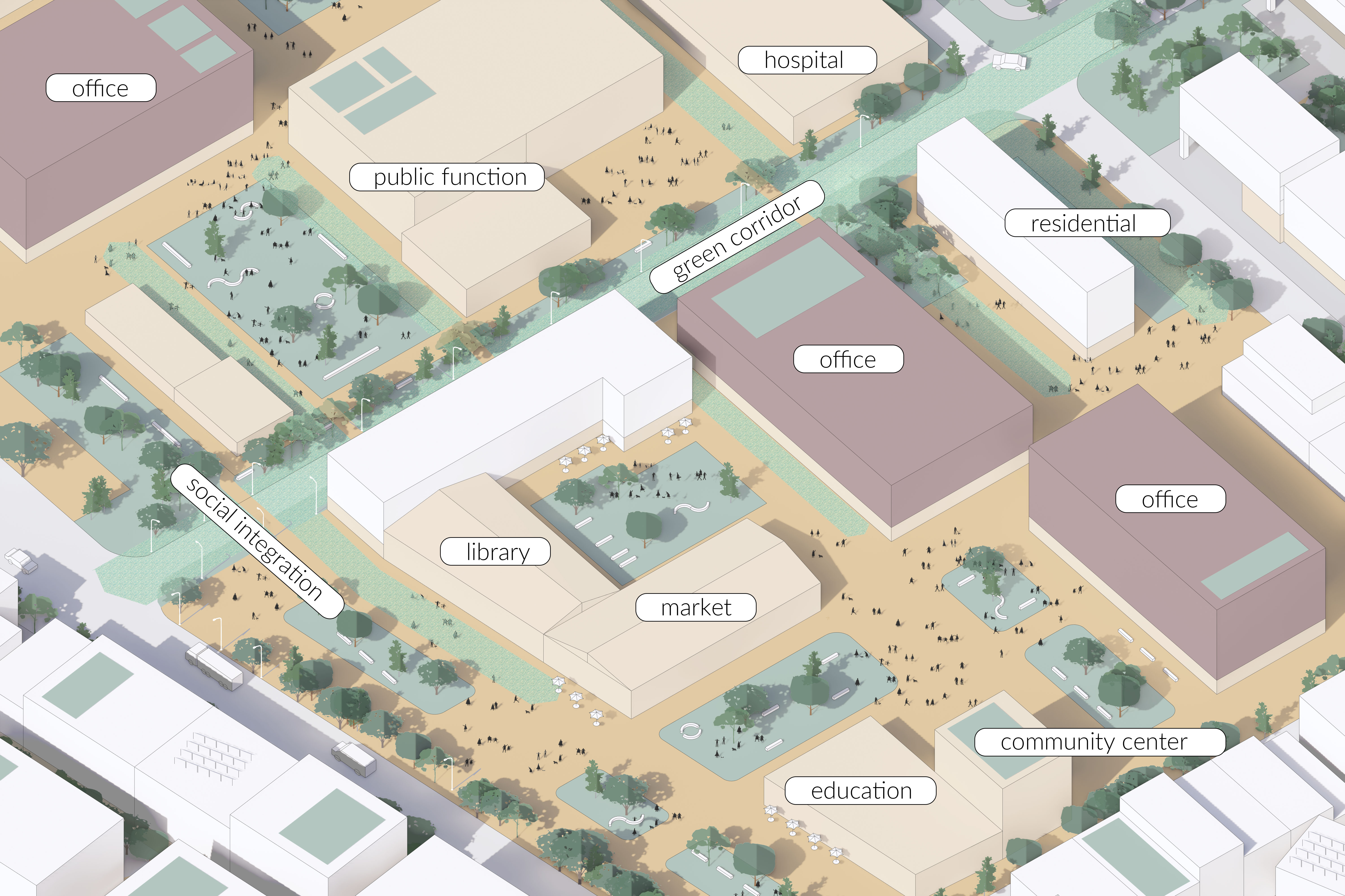
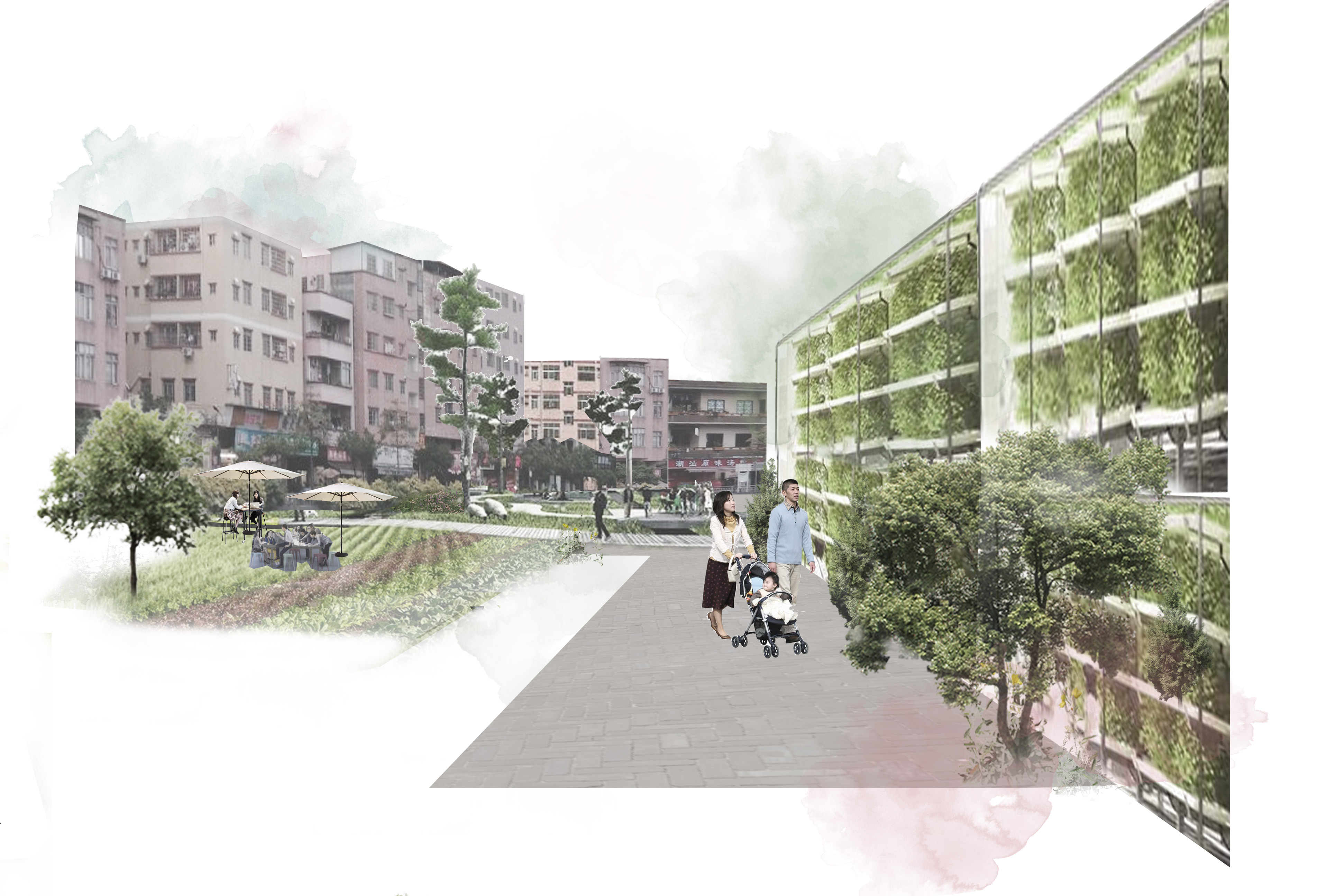
During the 2010s, Dongguan was marked by the transition from lower-end manufacturing to higher-end manufacturing, leading to rising wages, and attracting more and more migrants. Consequently, seventy-five per cent of the population are migrant workers.


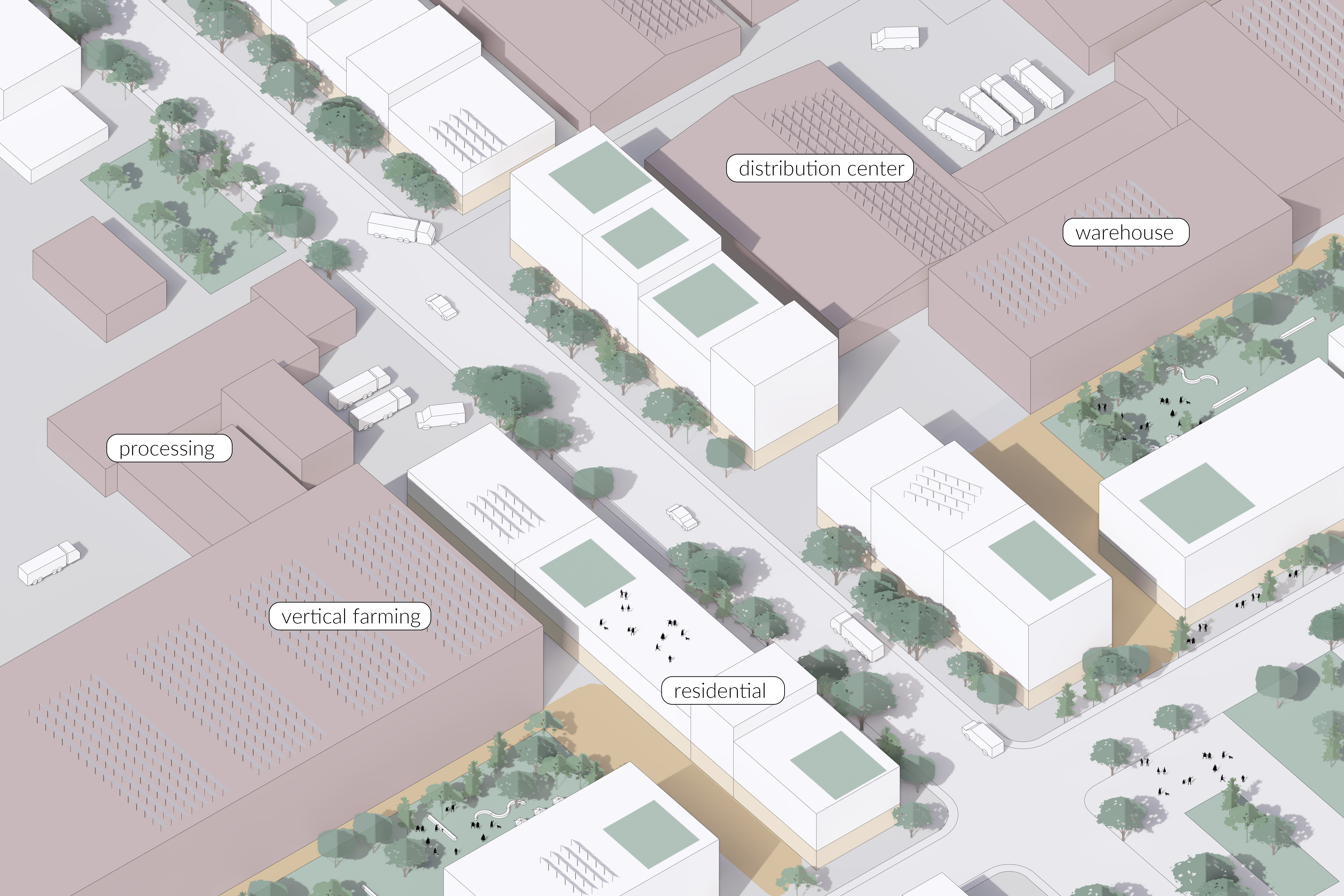
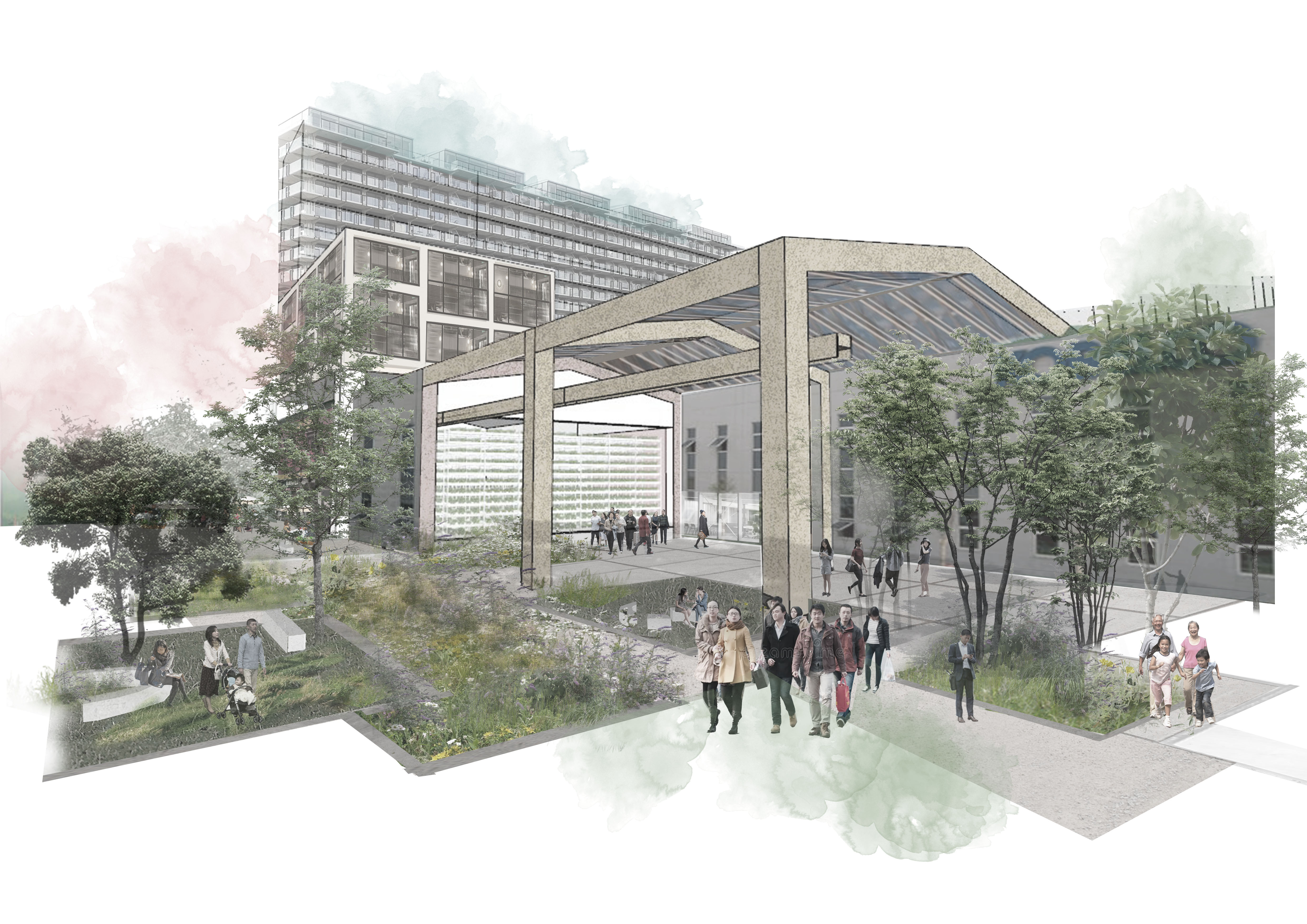
However, following the global financial crisis of 2020 following the Global Covid19 pandemic, rising labour costs and regional competition compelled Dongguan's once-thriving manufacturing industry to seek reinvention. Leaving many factories vacant and many migrants unemployed (Gao, 2020; Keegan, 2018).


Map highlighting the city's boroughs' potential for redevelopment

Dongguan, the future Food Factory of the GBA is rich in different spatial characteristics. Such as the mountainous structures that are scattered around the city, the Delta morphology on the west side, and the clear division between the industrial areas to the north while the local agriculture is situated to the south. Urban landscapes are enclaved by these spatial elements and existing infrastructural lines create connectivity between them and outside Dongguan. The convergence of these entities forms identities and has been clustered in six districts in which each potential has been considered.

The Necklace Metropole vision applied on the meso-scale at the city of Dongguan

Dongguan, the vertical factory

Dongguan has long and rich agricultural history, being the centre of its rural surroundings. Accordingly, the vision reemphasises this cultural significance while likewise leveraging its unique geography that combines agriculture, aquaculture, and urban, and natural spaces in proximity. Moreover, its current location along the two connecting high-speed rail lines in the GBA implies the potential to take advantage of this strategic position. By integrating the agricultural and urban networks, a multitude of opportunities arise. These opportunities address the current reliance on foreign food imports and the growing demand for increased food production due to regional population growth. The prepossessed spatial reorganisation takes these existing qualities but elevates them to the forefront of the development strategy. Dongguan will undergo a transformation into an agricultural technologies and production hub, entailing that it will become the GBA’s centre for agricultural industries and research.


The operationalisation of the flow network as envisioned in the vision

At the regional level, Dongguan needs to actively participate on all scales to allow synergies to foster. This entails both within the city and the region, the establishment of strong connections between the clusters of population, jobs, and ecology. This will rely on mesoscale intervention, wherein marginalized areas are linked to their respective adjacent developed areas, forming functional clusters. Dongguan illustrates this principle through the implementation of a smaller-scale necklace, connecting each of its functional clusters. Moreover, these clusters derive their characterization from their spatial strengths and opportunities combined with the development principles, resulting in an endogenous, multifunctional, and inclusive network.

The development principles from the vision applied to the meso-scale Dongguan

As a result, the city and its surrounding areas are expected to experience significant revitalisation, which will skilfully blend the pressure of new development with ecological resilience in its delicate landscape. This integration of growth and opportunity with environmental sensitivity will create a harmonious balance. Developing Dongguan as a prominent regional player, ushering in a new era for the city while empowering its marginalized people and landscapes to flourish in a resilient future, fostering self-sufficiency and sustainability.

The location of the micro-scale, the quarter of Shangdong village in the city of Dongguan

The territorialisation of the microscale Shangdong village, Qishi town, Dongguan

The location of Shangdong village Qishi town was strategically chosen as an example of a marginalized factory village, an urban village adjected to a factory quarter, at the edge of the city. Showcasing a vigorous landscape containing patches of urbanisation, industries, croplands, and traditional dyke-pond systems which produces a fragmented but dynamic landscape. Moreover, its strategic location along the Dōnghé River implies further opportunities to combine climate adaptation with the revitalisation of an industrially polluted landscape. Summarizing Dongguan’s’ challenges at the micro-scale, making it a recipient of the vision on a smaller scale.

The Necklace Metropole vision applied on the micro-scale at the city of Shangdong

The village of Shangdong, a qualitative urban quarter focused on agroindustry

The village of Shangdong exemplifies the potential of the necklace to breathe new life into both a marginalized city on a larger scale and a marginalized factory village on a smaller scale. Its aim is to Diminish the development gap between prosperous and marginalized areas, thereby fostering local economic growth, environmental sustainability, and social justice. The micro-scale landscape comprises a vibrant yet presently fragmented amalgamation of farmland, dyke-ponds, factories, residences, and a river.

The situation in Shangdong village Dongguan

Based on the overarching development strategy for the GBA, the city of Dongguan is set to become a hub for agricultural technology and production. Its primary goal is to ensure an abundant food supply for the GBA and its surrounding areas. To achieve this, Dongguan is designed as an agricultural development region, with a specific set of spatial policies and incentives designed to support both existing and new agro-industries. The city aims to foster collaborations among agricultural enterprises by providing assistance in terms of production facilities, resources, and research opportunities. Dongguan also possesses the capacity to establish connections across the entire agricultural value chain, linking farmers, food processing units, research and innovation centres, and distributors. A crucial aspect of this strategy involves actively involving the local population through participation in retraining programs, enabling them to adapt to transformative changes. This is reflected spatially through the presence of community service centres and schools dedicated to offering such training.

The series of micro-scale isometric drawings exemplify what the agricultural development region entails. The area, characterized by an amalgam of agricultural lands, village settlements, and industries, showcases specific strategies for promoting agroindustry while preserving local identity and culture. Most notable is the reorganisation of the special sectors, which currently exhibit an almost modernistic functional zoning, subsequently, the strategies are aimed at breaking up these homogeneous sectors to diversify them. Leading to attracting flows of different sorts to and through the area, creating new connections and flows.

The central focus of the town's strategy revolves around enhancing its service offerings. These added services aim to bolster the community's economic development while preserving its cultural identity. One approach involves introducing a new marketplace to promote local products. Additionally, the strategy entails establishing community centres, schools, and other facilities. By doing so, the overall quality of life in the area improves, while the community's resilience and adaptability are strengthened.

Within the former factory villages, an approach of diversification through the implementation of services, public spaces and green is applied. Aimed at promoting placemaking activities and increasing spatial quality. This strategy to diversify is envisioned to facilitate the exchange and dissemination of knowledge regarding the new industries and create social cohesion through community building and placemaking.

The factory districts are undergoing a process of diversification and revitalization to accommodate agricultural industries. Certain areas will be repurposed as food processing plants, while a significant portion will be transformed into self-sustaining vertical farms. These vertical farms will play a crucial role in producing a substantial portion of the food required for the GBA.

The agricultural plots undergo partial conversion to accommodate agroforestry in symbiosis with traditional dyke pond aquaculture and the reimagining of the natural riverbanks to achieve an environmental equilibrium and resilience, while simultaneously offering a place for recreational opportunities. The production activities in these areas serve multiple purposes. Firstly, it supports the operation of vertical farms by providing the necessary resources and inputs. Secondly, it caters to the production of goods that cannot be cultivated within vertical farms. Lastly, it provides support to the traditional paper industries by supplying the required natural fibres.

A portion of the factory zone is dedicated to diversification through the integration of residential dwellings. This entails introducing additional services and public spaces interspersed among the factories and residences, resulting in a true mixed-use area. This mixed-use approach prevents the quarter from being solely defined by its previous marginalized state. Moreover, it facilitates the blending of the existing homogenous community with other creative individuals and highly educated residents, fostering a dynamic and resilient population from a resident’s perspective. The factories within this zone share a similar focus on the agricultural industry, aligning with the objectives of the other zones.


Consequently, Shangdong village ascertains a socio-ecological equilibrium that prioritizes healthy living environments by seeking harmony between human activities and the area's natural environment. Revitalizing the marginalized areas and creating a more equitable urbanization model for the Greater Bay Area.

The Necklace Metropole

The Greater Bay Area’s current prioritization of economic growth gave rise to disparities between integrated cores and undefined marginalized areas, and adversely impacted society, ecology, and prosperity, leading to a disrupted and fragmented delta landscape. The vision for the Greater Bay Area focuses on these marginalized areas, advocating for their integration into an urbanisation model of spatial and social harmony through connectivity. Leveraging a socio-ecological equilibrium has the potential to address imbalances at multiple scales fostering a socially and environmentally resilient mega-region. Allowing the Greater Bay Area to be a delta acting as the gateway between the world and China. Emphasises the delta’s natural ability to connect and transition landscapes in equilibrium, a socio-ecological equilibrium.


Revitalized Marginalized landscapes, Socio-ecological equilibrium, Supportive necklace polycentric model